IMAGES TAKEN NEAR TO
Chynance, REDRUTH, TR16 4NL
Introduction
This page details the photographs taken nearby to Chynance, TR16 4NL by members of the Geograph project.
The Geograph project started in 2005 with the aim of publishing, organising and preserving representative images for every square kilometre of Great Britain, Ireland and the Isle of Man.

There are currently over 7.5m images from over14,400 individuals and you can help contribute to the project by visiting https://www.geograph.org.uk
Image Map
Images are licensed for reuse under creativecommons.org/licenses/by-sa/2.0
Notes
- Clicking on the map will re-center to the selected point.
- The higher the marker number, the further away the image location is from the centre of the postcode.
Image Listing (147 Images Found)
Images are licensed for reuse under creativecommons.org/licenses/by-sa/2.0
Image
Details
Distance
1
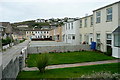
Houses at Portreath
These seem to face each other 'back-to-back' with this path rather than a road running between the front gardens.
Image: © Graham Horn
Taken: 21 Oct 2011
0.01 miles
2
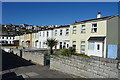
Terraced Houses
My companion was trying to find the house where he had lived for a short time with his family several decades ago. It wasn't easy when so many of the houses look silimar.
Image: © Anne Burgess
Taken: 11 May 2018
0.01 miles
4
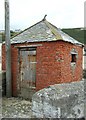
Rope store, Portreath Harbour
I was told that this small weathered red brick structure is probably the old harbour rope store where the ropes for warping vessels in and out of the harbour would be stored.
This tiny fragment is about all that remains of the thriving C19th industrial port complex that once occupied this site.
Image: © Simon Huguet
Taken: 11 Aug 2008
0.03 miles
6
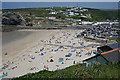
Portreath Beach
On a Saturday afternoon in June, while some get themselves wet in the sea, others are basking in the sunshine on the dry sand at the beach front.
Image: © Tony Atkin
Taken: 17 Jun 2006
0.03 miles
8
Portreath
Rather surprisingly, the centre of the village is made up of identikit rows of terraced houses.
Image: © Anne Burgess
Taken: 11 May 2018
0.04 miles
9
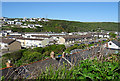
Portreath from the south
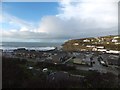
Portreath developed on either side of the river, as a port for shipping tin and other minerals, as well as hosting a small fishing fleet. The modern houses close to the sea have been built on the site of former harbour buildings and quays. The village expanded up the steep slopes either side of the village with improved transport links in the 19th and 20th centuries.
Image: © David Smith
Taken: 16 Jan 2014
0.04 miles
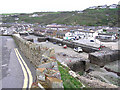
10
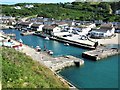
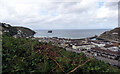
Portreath Harbour
Portreath is a village and fishing port on the north coast of Cornwall about three miles north-west of Redruth. The harbour we see today was started in 1760 and extended twice in the 19th century.
Image: © G Laird
Taken: 2 Jul 2019
0.05 miles