IMAGES TAKEN NEAR TO
Kingsley Terrace, REDRUTH, TR16 4LX
Introduction
This page details the photographs taken nearby to Kingsley Terrace, TR16 4LX by members of the Geograph project.
The Geograph project started in 2005 with the aim of publishing, organising and preserving representative images for every square kilometre of Great Britain, Ireland and the Isle of Man.

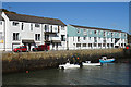
There are currently over 7.5m images from over14,400 individuals and you can help contribute to the project by visiting https://www.geograph.org.uk
Image Map (Loading...)


Getting Data...Please wait
Leaflet Map data © OpenStreetMap
Images are licensed for reuse under creativecommons.org/licenses/by-sa/2.0
Notes
- Clicking on the map will re-center to the selected point.
- The higher the marker number, the further away the image location is from the centre of the postcode.
Image Listing (161 Images Found)
Images are licensed for reuse under creativecommons.org/licenses/by-sa/2.0
Image
Details
Distance
1
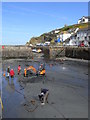
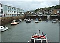
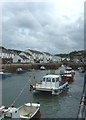
Portreath Inner Harbour
Don't know why they can't use a bucket and spade like everybody else.
Image: © Chris Allen
Taken: 11 Apr 2009
0.01 miles
2
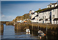
The harbour Portreath
The harbour and harbour side apartments, in the early morning winter sunshine.
Image: © David P Howard
Taken: 13 Jan 2016
0.01 miles
3
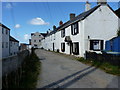
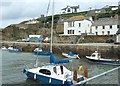
Fishermen's cottages just behind the harbour
The former view onto the harbour from the front windows of this row of cottages has been completely blocked by the (frankly insensitive) modern developments on the left.
Image: © Richard Law
Taken: 18 Sep 2012
0.01 miles
4
Portreath, Cornwall
Inner tidal basin, built as an extension to the harbour in 1846.
Image: © David Lewis
Taken: 9 Nov 2021
0.02 miles
5
Harbourside Housing
New blocks of flats have been built along the harbour wall.
Image: © Anne Burgess
Taken: 11 May 2018
0.02 miles
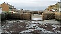
6
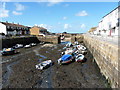
Portreath Inner Harbour, with the tide out
There's a strong smell of decomposing seaweed in these conditions.
Image: © Richard Law
Taken: 18 Sep 2012
0.02 miles
7
Inner Harbour basin, Portreath
The inner harbour was built in 1848. This was needed because at the height of the copper trade with Wales from about 1830 the outer harbour was not large enough, holding as it did 'only' 25 coastal sailing craft.
Image: © Simon Huguet
Taken: 11 Aug 2008
0.02 miles
8
Portreath Harbour
Portreath is a village and fishing port on the north coast of Cornwall about three miles north-west of Redruth. The harbour we see today was started in 1760 and extended twice in the 19th century.
Image: © G Laird
Taken: 2 Jul 2019
0.03 miles
9
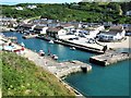
Outer harbour, Portreath
This is the original harbour harbut basin built inland of the 1760 pier in about 1801. It was used to ship copper ore across to Wales to be smelted and to bring in Welsh coal on the return journey to power the steam pumping engines on the local mines.
Local fishermen also used the harbour, and a thriving trade developed here fishing for pilchards.
Image: © Simon Huguet
Taken: 11 Aug 2008
0.04 miles
10
Outer Harbour, Portreath
The outer harbour was built in 1801 to export copper ore to Wales and import Welsh coal in return to power the steam engines that pumped the Cornish mines. The white house with the bay windows is the former Harbour Office which was still in use up to the 1930s.
The small stone building on the skyline by the blue forestay of the yacht is the 'Pepperpot'. This was built around 1800 to serve as a Pilot's lookout.
Image: © Simon Huguet
Taken: 11 Aug 2008
0.04 miles