IMAGES TAKEN NEAR TO
West Park, REDRUTH, TR15 3GE
Introduction
This page details the photographs taken nearby to West Park, TR15 3GE by members of the Geograph project.
The Geograph project started in 2005 with the aim of publishing, organising and preserving representative images for every square kilometre of Great Britain, Ireland and the Isle of Man.

There are currently over 7.5m images from over14,400 individuals and you can help contribute to the project by visiting https://www.geograph.org.uk
Image Map
Images are licensed for reuse under creativecommons.org/licenses/by-sa/2.0
Notes
- Clicking on the map will re-center to the selected point.
- The higher the marker number, the further away the image location is from the centre of the postcode.
Image Listing (36 Images Found)
Images are licensed for reuse under creativecommons.org/licenses/by-sa/2.0
Image
Details
Distance
1
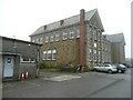
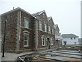
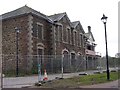
Redruth Grammar School
The victorian building is now home to Krowji, which, according to its website is; "Cornwall’s biggest creative sector cluster, providing studios, workspaces, offices, a café, meeting rooms and other facilities for a wide range of creative businesses at the Old Grammar School buildings in Redruth".
Image: © Jonathan Billinger
Taken: 2 Apr 2008
0.02 miles
2
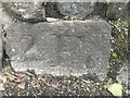
Old Boundary Marker on West End, Redruth
Mine Boundary Marker at the foot of the stone wall on the north side of West End 40 metres west of the church of The Assumption. Redruth parish. Inscribed B for the Basset mining sett.
Milestone Society National ID: CW_REDRU15em
Image: © P Barnett
Taken: 22 Mar 2023
0.06 miles
4
Church of the Assumption
Catholic Parish of Our Lady of All Nations.
Image: © Paul Barnett
Taken: 28 Sep 2014
0.09 miles
5
Former Women's Hospital, Redruth
In the final stages of redevelopment into live-work units (whatever that means).
Compare Image just over 2 years ago.
This building has significance for the photographer; place of birth.
Image: © Jonathan Billinger
Taken: 2 Apr 2008
0.09 miles
7
Old Boundary marker on West End, Redruth
The boundary marker is on the north of the road
within a wall outside Lowena, West End, 50m west of Penventon hotel entrance. Redruth parish (Kerrier district). It marks the boundary of the Basset sett mining area.
Inscription reads:-
2F
Milestone Society National ID: CW_REDRU10em
Image: © Paul Barnett
Taken: 20 Feb 2023
0.10 miles
8
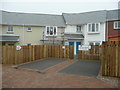
Affordable show house
Part of the redevelopment of the former hospital in Redruth into an "urban village".
Image: © Jonathan Billinger
Taken: 2 Apr 2008
0.11 miles
9
Derelict Hospital
The former Miner's and Women's Hospital in Redruth is now part of redevelopment plans for an "urban village".
Image: © Tony Atkin
Taken: 30 Dec 2005
0.12 miles
10
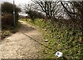
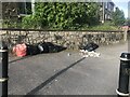
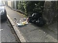
Path by A3047
The path leads from Redruth School (and from the nearby Tesco, as the litter suggests) to the junction of West Park with the dual carriageway, which is just off to the right. Is this the former road?
Image: © Derek Harper
Taken: 23 Feb 2009
0.13 miles