IMAGES TAKEN NEAR TO
Station Hill, REDRUTH, TR15 2PW
Introduction
This page details the photographs taken nearby to Station Hill, TR15 2PW by members of the Geograph project.
The Geograph project started in 2005 with the aim of publishing, organising and preserving representative images for every square kilometre of Great Britain, Ireland and the Isle of Man.

There are currently over 7.5m images from over14,400 individuals and you can help contribute to the project by visiting https://www.geograph.org.uk
Image Map
Images are licensed for reuse under creativecommons.org/licenses/by-sa/2.0
Notes
- Clicking on the map will re-center to the selected point.
- The higher the marker number, the further away the image location is from the centre of the postcode.
Image Listing (302 Images Found)
Images are licensed for reuse under creativecommons.org/licenses/by-sa/2.0
Image
Details
Distance
1
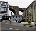
Two-storey house dwarfed by three structures, Redruth
Viewed across Station Hill. Charlie's Bar http://www.geograph.org.uk/photo/4983140 is on the left, Redruth Baptist
Church http://www.geograph.org.uk/photo/4983133is on the right and part of a railway viaduct is in the background.
Image: © Jaggery
Taken: 4 Jun 2016
0.00 miles
2
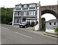
Charlie's Bar, Redruth
Located near a railway viaduct, viewed across Station Hill in early June 2016.
A June 2011 Google Earth Street View shows Gaslights Bar & Lounge here.
Image: © Jaggery
Taken: 4 Jun 2016
0.01 miles
3
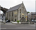
Redruth Baptist Church, Redruth
This is the Station Hill side of the church on the corner of the B3300. The church's website states that Redruth Baptist Church began when Opie Smith came down at Christmas 1801, hired a room in the town and held preaching meetings. By August 1802, four people were ready to be baptised by full immersion on profession of faith at Blowing House Bridge, near Carn Brea Hill. In the evening these four men were the first members of the newly constituted Baptist Church.
By 1866 the first Baptist Church building stood where the Town Cafe is now in Baptist Court.
In view is the second church building, erected at a cost £1367. It opened in 1877.
Image: © Jaggery
Taken: 4 Jun 2016
0.01 miles
4
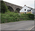
Two arches of a railway viaduct above Station Hill, Redruth
Southwest of Redruth railway station, the viaduct carries the Cornish Main Line railway.
Charlie's Bar http://www.geograph.org.uk/photo/4983140 is on the right.
Image: © Jaggery
Taken: 4 Jun 2016
0.01 miles
5
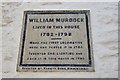
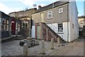
William Murdoch's House - Redruth
Erected by Tangye, a fellow industrialist from the area.
Image: © Ashley Dace
Taken: 24 Nov 2013
0.02 miles
7
William Murdoch's House - Redruth
This is quite an important house, possibly the first in the world to be lit by gas! William Murdoch used coal gas, nowadays all houses use natural gas.
Image: © Ashley Dace
Taken: 24 Nov 2013
0.02 miles
8
William Murdoch's House - Redruth
This is quite an important house, possibly the first in the world to be lit by gas! William Murdoch used coal gas, nowadays all houses use natural gas.
Image: © Ashley Dace
Taken: 24 Nov 2013
0.02 miles
9
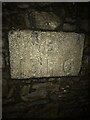
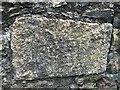
Boundary stone
B13 F6
Milestone Society National ID: CW_REDRU01em
Image: © Paul Barnett
Taken: 5 Dec 2022
0.02 miles
10
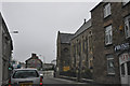
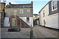
Redruth : Penryn Street B3300
Looking along Penryn Street as it heads through Redruth.
Image: © Lewis Clarke
Taken: 13 Jul 2015
0.03 miles