IMAGES TAKEN NEAR TO
South Downs/South Drive, South Downs, REDRUTH, TR15 2NN
Introduction
This page details the photographs taken nearby to South Downs/South Drive, South Downs, TR15 2NN by members of the Geograph project.
The Geograph project started in 2005 with the aim of publishing, organising and preserving representative images for every square kilometre of Great Britain, Ireland and the Isle of Man.

There are currently over 7.5m images from over14,400 individuals and you can help contribute to the project by visiting https://www.geograph.org.uk
Image Map
Images are licensed for reuse under creativecommons.org/licenses/by-sa/2.0
Notes
- Clicking on the map will re-center to the selected point.
- The higher the marker number, the further away the image location is from the centre of the postcode.
Image Listing (9 Images Found)
Images are licensed for reuse under creativecommons.org/licenses/by-sa/2.0
Image
Details
Distance
1
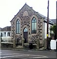
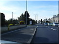
Redruth Wesleyan chapel
By main roundabout
Image: © Paul Barnett
Taken: 28 Oct 2015
0.02 miles
2
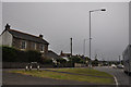
Redruth : South Downs B3300
Looking along B3300 South Downs road.
Image: © Lewis Clarke
Taken: 13 Jul 2015
0.07 miles
3
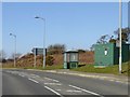
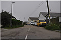
Bus shelter, Sandy Lane, Redruth
Sandy Lane here is the edge of the built-up area
Image: © David Smith
Taken: 14 Mar 2016
0.08 miles
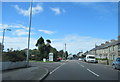
5
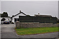
Redruth : 110 Lanner Hill
A bungalow on Lanner Hill.
Image: © Lewis Clarke
Taken: 13 Jul 2015
0.16 miles
6
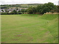
Clijah Croft
Recreation ground outside Redruth
Image: © Sheila Russell
Taken: 6 Aug 2005
0.19 miles
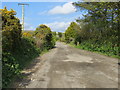
7
Redruth : Road
A road off of the A393 in Cornwall.
Image: © Lewis Clarke
Taken: 13 Jul 2015
0.21 miles
9
Mining Trail Track to Carn Marth
Looking north-eastward.
Image: © Peter Wood
Taken: 2 May 2017
0.22 miles