IMAGES TAKEN NEAR TO
Raymond Road, REDRUTH, TR15 2HF
Introduction
This page details the photographs taken nearby to Raymond Road, TR15 2HF by members of the Geograph project.
The Geograph project started in 2005 with the aim of publishing, organising and preserving representative images for every square kilometre of Great Britain, Ireland and the Isle of Man.

There are currently over 7.5m images from over14,400 individuals and you can help contribute to the project by visiting https://www.geograph.org.uk
Image Map
Images are licensed for reuse under creativecommons.org/licenses/by-sa/2.0
Notes
- Clicking on the map will re-center to the selected point.
- The higher the marker number, the further away the image location is from the centre of the postcode.
Image Listing (41 Images Found)
Images are licensed for reuse under creativecommons.org/licenses/by-sa/2.0
Image
Details
Distance
4
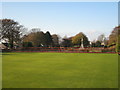
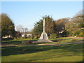
Bowling green in Victoria Park Redruth
In the background can be seen the war memorial.
Image: © Rod Allday
Taken: 4 Nov 2008
0.15 miles
6
Pednandrea stack, Redruth
A shortened former mine chimney that appears to be in the garden of a house in Redruth.
Image: © Chris Allen
Taken: 16 May 2019
0.16 miles
7
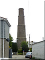
Pednandrea stack, Redruth
An unusual telescope-like chimney that has been shortened and was formerly on a mine. It is now in somebody's garden.
Image: © Chris Allen
Taken: 16 May 2019
0.16 miles
9
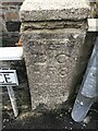
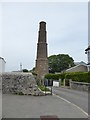
Old Boundary Marker on Heanton Terrace, Redruth
Mine Boundary Marker on the north side of Heanton Terrace, set in the front garden wall of No 26. Redruth parish. Inscribed B C / - F 8. The stone records the Fairmeadow mining sett boundary.
Milestone Society National ID: CW_REDRU14em
Image: © P Barnett
Taken: 20 Mar 2023
0.20 miles
10
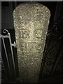
Boundary stone on Heanton Villas
Carved stone post on the north of the road outside house number 26.
BC
4F6
CW_REDRU05em
Image: © Paul Barnett
Taken: 10 Feb 2023
0.20 miles