IMAGES TAKEN NEAR TO
Brea, CAMBORNE, TR14 9DG
Introduction
This page details the photographs taken nearby to TR14 9DG by members of the Geograph project.
The Geograph project started in 2005 with the aim of publishing, organising and preserving representative images for every square kilometre of Great Britain, Ireland and the Isle of Man.

There are currently over 7.5m images from over14,400 individuals and you can help contribute to the project by visiting https://www.geograph.org.uk
Image Map
Images are licensed for reuse under creativecommons.org/licenses/by-sa/2.0
Notes
- Clicking on the map will re-center to the selected point.
- The higher the marker number, the further away the image location is from the centre of the postcode.
Image Listing (32 Images Found)
Images are licensed for reuse under creativecommons.org/licenses/by-sa/2.0
Image
Details
Distance
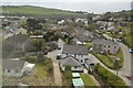
1
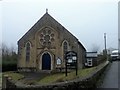
Brea Methodist church
On back road just East of tunnel
Image: © Paul Barnett
Taken: 18 Oct 2015
0.03 miles
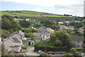
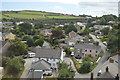
2
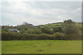
Higher Brea
Looking over the upper part of Brea village from the Great Flat Lode Trail.
Image: © Tony Atkin
Taken: 24 Aug 2007
0.07 miles
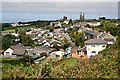
5
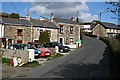
Brea Village
Brea is a mining village in the Red River Valley which is separated from the nearby conurbation by a railway embankment over the valley through which there is only a narrow single track road tunnel.
Image: © Tony Atkin
Taken: 3 Mar 2007
0.10 miles
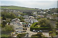
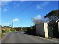
8
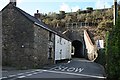
Brea Tunnel
A narrow single-track road tunnel goes through the railway embankment over the Red River valley.
Image: © Tony Atkin
Taken: 3 Mar 2007
0.12 miles