IMAGES TAKEN NEAR TO
Llawnroc Close, CAMBORNE, TR14 7AS
Introduction
This page details the photographs taken nearby to Llawnroc Close, TR14 7AS by members of the Geograph project.
The Geograph project started in 2005 with the aim of publishing, organising and preserving representative images for every square kilometre of Great Britain, Ireland and the Isle of Man.

There are currently over 7.5m images from over14,400 individuals and you can help contribute to the project by visiting https://www.geograph.org.uk
Image Map (Loading...)


Getting Data...Please wait
Leaflet Map data © OpenStreetMap
Images are licensed for reuse under creativecommons.org/licenses/by-sa/2.0
Notes
- Clicking on the map will re-center to the selected point.
- The higher the marker number, the further away the image location is from the centre of the postcode.
Image Listing (14 Images Found)
Images are licensed for reuse under creativecommons.org/licenses/by-sa/2.0
Image
Details
Distance
1
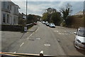
Stray Park Road level crossing, Camborne
Image: © Roy Hughes
Taken: 14 Sep 2019
0.16 miles
4
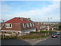
'Cornish Unit' houses on the Beacon Estate
The Cornish Unit was a type of house using prefabricated construction techniques, erected by local authorities throughout Britain during the post-war period, up to the 1960s. The originators of the system were Selleck Nicholls and Williams (SNW), based in St Austell, hence the Cornish Unit name. About 30,000 of this type of house were built. The system used precast concrete posts and planks to form the ground floor walls, topped by a timber mansard construction to form the 1st floor walls and roof. By its nature, the wall construction has been susceptible to failure through degradation of the concrete and its reinforcement and because of this the houses can be difficult to mortgage. There are various schemes of replacing these walls, carried out by licensed contractors who are approved by mortgage providers.
Image: © Rod Allday
Taken: 22 Oct 2010
0.18 miles
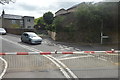
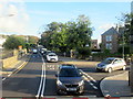
6
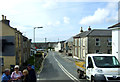
Stray Park Road, Camborne
View from the level crossing.
Image: © JThomas
Taken: 10 Jul 2017
0.20 miles
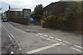
7
Trevu Road
View towards Camborne Railway Station and the town library, from Trevu Road.
Image: © Sue Woollatt
Taken: 4 Mar 2011
0.22 miles
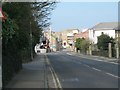
8
Stray Park Road, Camborne
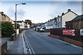
View south east along Stray Park Road from the junction with Trevenson Street.
Image: © David P Howard
Taken: 12 Jan 2016
0.23 miles
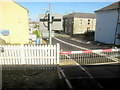
9
Trevu Road level crossing, Camborne looking southwestwards.
Image: © Roy Hughes
Taken: 14 Sep 2019
0.24 miles