IMAGES TAKEN NEAR TO
Treswithian Downs, CAMBORNE, TR14 0BY
Introduction
This page details the photographs taken nearby to TR14 0BY by members of the Geograph project.
The Geograph project started in 2005 with the aim of publishing, organising and preserving representative images for every square kilometre of Great Britain, Ireland and the Isle of Man.

There are currently over 7.5m images from over14,400 individuals and you can help contribute to the project by visiting https://www.geograph.org.uk
Image Map
Images are licensed for reuse under creativecommons.org/licenses/by-sa/2.0
Notes
- Clicking on the map will re-center to the selected point.
- The higher the marker number, the further away the image location is from the centre of the postcode.
Image Listing (6 Images Found)
Images are licensed for reuse under creativecommons.org/licenses/by-sa/2.0
Image
Details
Distance
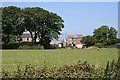
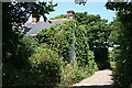
1
Track to New Downs Farm
The farm entrance track to the left is a bridleway. So is the one to the right, grass covered, where an additional "no motorcycling" sign has had to be erected.
Image: © Graham Horn
Taken: 19 Oct 2011
0.10 miles
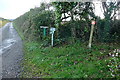
2
Meteorological Station
It is operated by the Met Office and although the gate is open the signs do not encourage access.
Image: © Graham Horn
Taken: 19 Oct 2011
0.17 miles
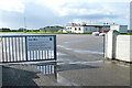
3
Kehelland School
The village school, with a mixture of Victorian and more recent buildings.
Image: © Graham Horn
Taken: 19 Oct 2011
0.17 miles
5
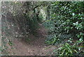
Bridleway towards New Downs
Like many, this bridleway is virtually a sunken lane with no view. Well, maybe if you are on a horse you get a view if you are not dodging the low branches.
Image: © Graham Horn
Taken: 19 Oct 2011
0.24 miles