IMAGES TAKEN NEAR TO
Granny Polly Lane, HELSTON, TR13 9TJ
Introduction
This page details the photographs taken nearby to Granny Polly Lane, TR13 9TJ by members of the Geograph project.
The Geograph project started in 2005 with the aim of publishing, organising and preserving representative images for every square kilometre of Great Britain, Ireland and the Isle of Man.

There are currently over 7.5m images from over14,400 individuals and you can help contribute to the project by visiting https://www.geograph.org.uk
Image Map
Images are licensed for reuse under creativecommons.org/licenses/by-sa/2.0
Notes
- Clicking on the map will re-center to the selected point.
- The higher the marker number, the further away the image location is from the centre of the postcode.
Image Listing (5 Images Found)
Images are licensed for reuse under creativecommons.org/licenses/by-sa/2.0
Image
Details
Distance
1
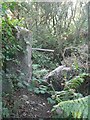
Old gate by the path, Mount Whistle, Tregonning Hill
Image: © Rich Tea
Taken: 1 Aug 2006
0.17 miles
2
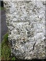
Benchmark Great Work, Godolphin Cross
Benchmark description https://www.bench-marks.org.uk/bm147836
Image: © OfficeOfPudseyBMs
Taken: 25 May 2021
0.19 miles
3
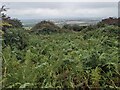
The outer wall of a 'Settlement'
I chose the wrong path to view this historic site. Another footpath, 100m to the NE, crosses the open aspect of the settlement, now part of a field.
Image: © David Medcalf
Taken: 12 Sep 2021
0.20 miles
4

Path leading to Mount Whistle Farm
This path is the main way to the farm
Image: © Raymond Cubberley
Taken: 23 Jun 2012
0.23 miles
5
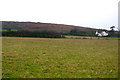
Towards Tregonning Hill
Looking across to the northern end of Tregonning Hill from the footpath that leads from Herland Farm to Tregonning.
Image: © Ian Capper
Taken: 23 Oct 2011
0.25 miles