IMAGES TAKEN NEAR TO
Wheal Vor, HELSTON, TR13 9NW
Introduction
This page details the photographs taken nearby to Wheal Vor, TR13 9NW by members of the Geograph project.
The Geograph project started in 2005 with the aim of publishing, organising and preserving representative images for every square kilometre of Great Britain, Ireland and the Isle of Man.

There are currently over 7.5m images from over14,400 individuals and you can help contribute to the project by visiting https://www.geograph.org.uk
Image Map (Loading...)


Getting Data...Please wait
Leaflet Map data © OpenStreetMap
Images are licensed for reuse under creativecommons.org/licenses/by-sa/2.0
Notes
- Clicking on the map will re-center to the selected point.
- The higher the marker number, the further away the image location is from the centre of the postcode.
Image Listing (2 Images Found)
Images are licensed for reuse under creativecommons.org/licenses/by-sa/2.0
Image
Details
Distance
1
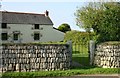
The Cottage
A well kept cottage with a very neat garden and wall
Image: © Ken Ballinger
Taken: 12 Sep 2005
0.11 miles
2
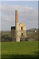
Wheal Vor
Wheal Vor's heyday was from 1812 to 1848. It was one of Cornwall's biggest and richest tin mines and employed around 1,200 people (men, women and children).
Image: © Elizabeth Scott
Taken: 14 Oct 2011
0.21 miles