IMAGES TAKEN NEAR TO
St. Elvan Crescent, HELSTON, TR13 9NA
Introduction
This page details the photographs taken nearby to St. Elvan Crescent, TR13 9NA by members of the Geograph project.
The Geograph project started in 2005 with the aim of publishing, organising and preserving representative images for every square kilometre of Great Britain, Ireland and the Isle of Man.

There are currently over 7.5m images from over14,400 individuals and you can help contribute to the project by visiting https://www.geograph.org.uk
Image Map
Images are licensed for reuse under creativecommons.org/licenses/by-sa/2.0
Notes
- Clicking on the map will re-center to the selected point.
- The higher the marker number, the further away the image location is from the centre of the postcode.
Image Listing (14 Images Found)
Images are licensed for reuse under creativecommons.org/licenses/by-sa/2.0
Image
Details
Distance
1
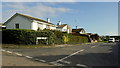
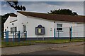
St. Elvan's Crescent
Housing on the northern edge of Porthleven.
Image: © Jonathan Billinger
Taken: 3 Oct 2013
0.01 miles
2
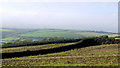
Arable fields north of Porthleven
The tower of Breage church can be seen in the distance.
Image: © Jonathan Billinger
Taken: 3 Oct 2013
0.15 miles
3
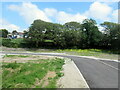
Entrance to new industrial estate Porthleven
Image: © Roy Hughes
Taken: 1 Jul 2021
0.15 miles
4
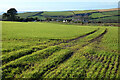
Farmland, Porthleven
Beside Torleven Road as it descends to the north-eastern corner of the village.
Image: © Andrew Smith
Taken: 2 Jan 2023
0.15 miles
5

Penponds Road
Bungalows in Penponds Road, Porthleven.
Image: © Elizabeth Scott
Taken: 9 Sep 2023
0.16 miles
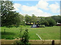
6
Porthleven School
Porthleven Primary School. The Family Hub is on the same site, see Image
Image: © Elizabeth Scott
Taken: 9 Sep 2023
0.17 miles
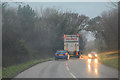
7
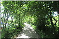
The B3304 passing through woodland on the road to Portleven
Image: © Roy Hughes
Taken: 30 Jun 2022
0.17 miles
9
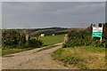
Treza Farm Campsite
Entrance to Treza Farm Campsite.
Image: © Elizabeth Scott
Taken: 9 Sep 2023
0.19 miles
10
Porthleven : Methleigh Bottoms B3304
Looking along Methleigh Bottoms.
Image: © Lewis Clarke
Taken: 18 Dec 2019
0.19 miles