IMAGES TAKEN NEAR TO
Porthleven, HELSTON, TR13 9LE
Introduction
This page details the photographs taken nearby to TR13 9LE by members of the Geograph project.
The Geograph project started in 2005 with the aim of publishing, organising and preserving representative images for every square kilometre of Great Britain, Ireland and the Isle of Man.

There are currently over 7.5m images from over14,400 individuals and you can help contribute to the project by visiting https://www.geograph.org.uk
Image Map (Loading...)


Getting Data...Please wait
Leaflet Map data © OpenStreetMap
Images are licensed for reuse under creativecommons.org/licenses/by-sa/2.0
Notes
- Clicking on the map will re-center to the selected point.
- The higher the marker number, the further away the image location is from the centre of the postcode.
Image Listing (6 Images Found)
Images are licensed for reuse under creativecommons.org/licenses/by-sa/2.0
Image
Details
Distance
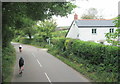
2
Porthleven : Methleigh Bottoms B3304
Looking along Methleigh Bottoms.
Image: © Lewis Clarke
Taken: 18 Dec 2019
0.18 miles
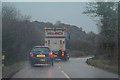
3
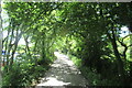
The B3304 passing through woodland on the road to Portleven
Image: © Roy Hughes
Taken: 30 Jun 2022
0.20 miles
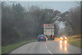
4
Breage : Methleigh Bottoms B3304
Heading along the B3304.
Image: © Lewis Clarke
Taken: 18 Dec 2019
0.22 miles
5
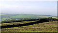
Arable fields north of Porthleven
The tower of Breage church can be seen in the distance.
Image: © Jonathan Billinger
Taken: 3 Oct 2013
0.23 miles
6
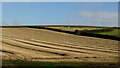
Straw and stubble rows
An arable field a few weeks after harvesting and as yet uncultivated.
Image: © Jonathan Billinger
Taken: 3 Oct 2013
0.24 miles