IMAGES TAKEN NEAR TO
Infirmary Hill, TRURO, TR1 2JA
Introduction
This page details the photographs taken nearby to Infirmary Hill, TR1 2JA by members of the Geograph project.
The Geograph project started in 2005 with the aim of publishing, organising and preserving representative images for every square kilometre of Great Britain, Ireland and the Isle of Man.

There are currently over 7.5m images from over14,400 individuals and you can help contribute to the project by visiting https://www.geograph.org.uk
Image Map
Images are licensed for reuse under creativecommons.org/licenses/by-sa/2.0
Notes
- Clicking on the map will re-center to the selected point.
- The higher the marker number, the further away the image location is from the centre of the postcode.
Image Listing (94 Images Found)
Images are licensed for reuse under creativecommons.org/licenses/by-sa/2.0
Image
Details
Distance
1
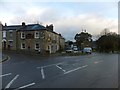
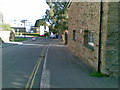
The Daniell Arms inn, on Falmouth Road, Truro
The Daniell family lived at Trelissick, on the River Fal south of Truro.
Image: © David Smith
Taken: 1 Feb 2013
0.02 miles
2
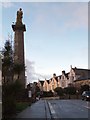
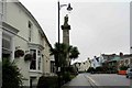
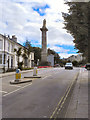
The Lander monument on Falmouth Road, Truro
This commemorates the Farmer brothers, and in particular Richard Lander, who explored the Niger River in West Africa. Beyond are some of the 19th century houses that line Falmouth Road
Image: © David Smith
Taken: 1 Feb 2013
0.03 miles
3
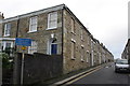
Daniell Street from Falmouth Road junction
On the near corner of the first house on the left is an OS benchmark Image
Image: © Roger Templeman
Taken: 12 Nov 2011
0.04 miles
4
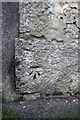
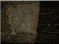
Benchmark on #2 Daniell Terrace
Ordnance Survey cut mark benchmark described on the Bench Mark Database at http://www.bench-marks.org.uk/bm40216
Image: © Roger Templeman
Taken: 12 Nov 2011
0.04 miles
5
Richard Lander Monument, Truro
Statue on column
Image: © www fotodiscs4u co uk
Taken: 12 Nov 2006
0.04 miles
6
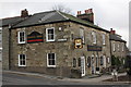
Daniell Arms at junction of Daniell Street and Infirmary Lane
The concrete skirt on the Daniell Street face of the pub may hide an Ordnance Survey cut mark benchmark levelled in 1850 at 110.263 ft above Ordnance Datum Liverpool. The mark is described on the Bench Mark Database at http://www.bench-marks.org.uk/bm40182
Image: © Roger Templeman
Taken: 12 Nov 2011
0.04 miles
8
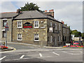
Daniell Arms
At the corner of Daniell Street and Lemon Street.
Image: © David Dixon
Taken: 28 Jul 2010
0.05 miles
10
Lemon Street
The top of Lemon Street, before it becomes Falmouth Road. Image] is prominent on the left hand side of the road.
Image: © David Dixon
Taken: 28 Jul 2010
0.06 miles