IMAGES TAKEN NEAR TO
Ruan Minor, HELSTON, TR12 7LP
Introduction
This page details the photographs taken nearby to TR12 7LP by members of the Geograph project.
The Geograph project started in 2005 with the aim of publishing, organising and preserving representative images for every square kilometre of Great Britain, Ireland and the Isle of Man.

There are currently over 7.5m images from over14,400 individuals and you can help contribute to the project by visiting https://www.geograph.org.uk
Image Map
Images are licensed for reuse under creativecommons.org/licenses/by-sa/2.0
Notes
- Clicking on the map will re-center to the selected point.
- The higher the marker number, the further away the image location is from the centre of the postcode.
Image Listing (38 Images Found)
Images are licensed for reuse under creativecommons.org/licenses/by-sa/2.0
Image
Details
Distance
1
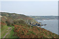
Landewednack: the South West Coast Path above Poltesco
Polbream Point is visible, just off Carleon Cove, Poltesco. Further along the coast: Kennack Sands
Image: © Martin Bodman
Taken: 25 Sep 2008
0.14 miles
2
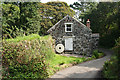
Landewednack: Upper or Higher Mill, Poltesco
Seen from the lane from Ruan Minor, the wall on the left, constructed from granite blocks, is in fact the embanked leat running to a preserved overshot waterwheel. Middle and Lower Mill have both been demolished
Image: © Martin Bodman
Taken: Unknown
0.16 miles
4
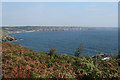
Landewednack: by Black Rock
View towards Polbream Point, above the bracken, left, and Lankidden Cove, beyond the small island, right. Black Rock is offshore, below the photographer, right
Image: © Martin Bodman
Taken: 25 Sep 2008
0.17 miles
5
Landewednack: Higher Mill, Poltesco
Little changed from my earlier shot taken a decade earlier. See Image Built of granite with a high level leat on an embankment formed of granite boulders, left. A waterwheel has been restored at the end of the leat
Image: © Martin Bodman
Taken: 25 Sep 2008
0.18 miles
6
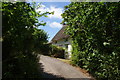
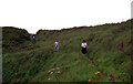
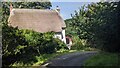
Thatched cottage by the lane to Poltesco
It is a fairly steep descent from Ruan Minor down to Poltesco.
Image: © Bill Boaden
Taken: 3 Jul 2014
0.19 miles
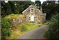
8
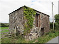
Ivy Clad barn on Poltesco Lane
Built of local stone and brick; on the left handside of the low door that faces the road is a Cut Benchmark, 50cm above ground level - 55.23m ASL.
https://www.bench-marks.org.uk/bm113721
Image: © Matthew Hatton
Taken: 7 Sep 2019
0.19 miles

10
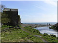
Poltesco beach
The building on the left is a warehouse that was associated with the ruinous serpentine works. The round building visible to the right of it is a winch/capstan house.
Image: © Chris Allen
Taken: 14 Apr 2009
0.20 miles