IMAGES TAKEN NEAR TO
Mullion, HELSTON, TR12 7JE
Introduction
This page details the photographs taken nearby to TR12 7JE by members of the Geograph project.
The Geograph project started in 2005 with the aim of publishing, organising and preserving representative images for every square kilometre of Great Britain, Ireland and the Isle of Man.

There are currently over 7.5m images from over14,400 individuals and you can help contribute to the project by visiting https://www.geograph.org.uk
Image Map
Images are licensed for reuse under creativecommons.org/licenses/by-sa/2.0
Notes
- Clicking on the map will re-center to the selected point.
- The higher the marker number, the further away the image location is from the centre of the postcode.
Image Listing (3 Images Found)
Images are licensed for reuse under creativecommons.org/licenses/by-sa/2.0
Image
Details
Distance
1
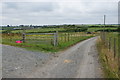
Polhorman Lane
It goes in the direction of Cury, of which the parish church can be seen far left, but you cannot get directly there because of a river valley with very few crossings.
Image: © Bill Boaden
Taken: 1 Jul 2014
0.17 miles
2
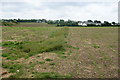
Footpath to Mullion
The parish church can be seen on the skyline.
Image: © Bill Boaden
Taken: 1 Jul 2014
0.19 miles
3
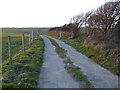
Track off Polhorman Lane
North of Mullion, the private lane runs down towards the steep valley which in turn terminates at the coast at Poldhu Cove.
Image: © Jonathan Billinger
Taken: 13 Mar 2007
0.25 miles