IMAGES TAKEN NEAR TO
Trenance, HELSTON, TR12 6QL
Introduction
This page details the photographs taken nearby to Trenance, TR12 6QL by members of the Geograph project.
The Geograph project started in 2005 with the aim of publishing, organising and preserving representative images for every square kilometre of Great Britain, Ireland and the Isle of Man.

There are currently over 7.5m images from over14,400 individuals and you can help contribute to the project by visiting https://www.geograph.org.uk
Image Map
Images are licensed for reuse under creativecommons.org/licenses/by-sa/2.0
Notes
- Clicking on the map will re-center to the selected point.
- The higher the marker number, the further away the image location is from the centre of the postcode.
Image Listing (17 Images Found)
Images are licensed for reuse under creativecommons.org/licenses/by-sa/2.0
Image
Details
Distance
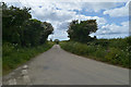
1
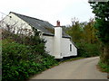
A typical Cornish roadside sight.
A whitewashed cottage by a twisting country lane.
Image: © Jonathan Billinger
Taken: 19 Nov 2009
0.03 miles
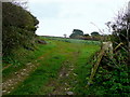
2
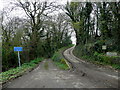
High or low road?
To the left is the public road to St. Keverne via the deep Trenoweth valley.
The track to the right leads to Trenance.
Image: © Jonathan Billinger
Taken: 19 Nov 2009
0.04 miles
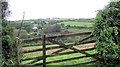
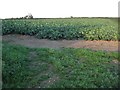
5
Vegetable land at Trenance
The crop is cauliflower - the main vegetable crop of west Cornwall.
Image: © Jonathan Billinger
Taken: 19 Nov 2009
0.06 miles
6
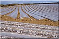
Neatly Covered Maize Seedlings
Maize needs a fairly warm soil temperature to start growing and this method of covering the seedbeds with plastic works well. The maize is grown as a fodder crop.
Image: © Tony Atkin
Taken: 8 Apr 2010
0.11 miles
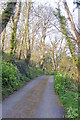
7
Field of cabbages
Field of cabbages beside a country road which is the route of the South West Coast Path between Porthoustock and Porthallow.
Image: © Philip Halling
Taken: 27 Sep 2010
0.16 miles
9
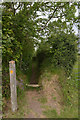
Stile on SW Coast Path
The SW Coast Path leaves a road to head across fields to Parc-An-Tidno.
Image: © habiloid
Taken: 28 May 2019
0.18 miles
10
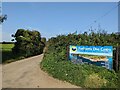
You're nearly there...
Signs for Porthkerris Dive Centre have been getting bigger and brighter closer to the actual Dive Centre.
Image: © David Medcalf
Taken: 9 Sep 2023
0.19 miles