IMAGES TAKEN NEAR TO
Mawgan, HELSTON, TR12 6AD
Introduction
This page details the photographs taken nearby to TR12 6AD by members of the Geograph project.
The Geograph project started in 2005 with the aim of publishing, organising and preserving representative images for every square kilometre of Great Britain, Ireland and the Isle of Man.

There are currently over 7.5m images from over14,400 individuals and you can help contribute to the project by visiting https://www.geograph.org.uk
Image Map
Images are licensed for reuse under creativecommons.org/licenses/by-sa/2.0
Notes
- Clicking on the map will re-center to the selected point.
- The higher the marker number, the further away the image location is from the centre of the postcode.
Image Listing (29 Images Found)
Images are licensed for reuse under creativecommons.org/licenses/by-sa/2.0
Image
Details
Distance
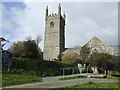
2
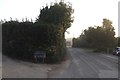
Entrance to Gwarth-an-drea
Passing the entrance way and heading towards the church in Mawgan.
Image: © Chris Thomas-Atkin
Taken: 15 Sep 2018
0.01 miles
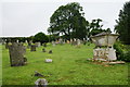
3
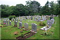
Cemetery in Mawgan
This is the overflow burial ground following closure of the churchyard.
Image: © Bill Boaden
Taken: 4 Jul 2014
0.02 miles
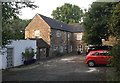
4
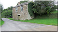
Church House
A simple building but unaltered, and one of a group of buildings near the church. It dates from the early 19th C and is Grade II listed, with English Heritage Building ID: 65319. It served as a vestry.
Image: © Stuart Logan
Taken: 11 Oct 2012
0.04 miles
6
The churchyard of St Mawgan-in-Meneage Parish Church
Now closed and the density of the graves has been reduced like so many churchyards.
Image: © Bill Boaden
Taken: 4 Jul 2014
0.05 miles
7
Glebe Hall
Glebe Hall a former coach house.
Image: © Chris Thomas-Atkin
Taken: 15 Sep 2018
0.06 miles
8
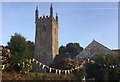
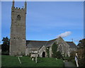
The Parish Church
The Parish Church in Mawgan-in-Meneage.
Image: © Chris Thomas-Atkin
Taken: 15 Sep 2018
0.06 miles
9
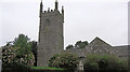
Church of Saint Maugan
English Heritage have listed this church Grade I and given it English Heritage Building ID: 65309. It is their spelling in the title. The building dates from the 13th C but was remodelled in the 15th C. The tower is typical of 15th C Cornish west towers and is a very complete example. For more detail see: http://www.britishlistedbuildings.co.uk/en-65309-church-of-saint-maugan-mawgan-in-meneage-
Image: © Stuart Logan
Taken: 11 Oct 2012
0.06 miles
10

The Ship Inn
The public house in the village of Mawgan-in-Meneage.
Image: © Chris Thomas-Atkin
Taken: 14 Sep 2018
0.06 miles