IMAGES TAKEN NEAR TO
Antron Hill, PENRYN, TR10 9HH
Introduction
This page details the photographs taken nearby to Antron Hill, TR10 9HH by members of the Geograph project.
The Geograph project started in 2005 with the aim of publishing, organising and preserving representative images for every square kilometre of Great Britain, Ireland and the Isle of Man.

There are currently over 7.5m images from over14,400 individuals and you can help contribute to the project by visiting https://www.geograph.org.uk
Image Map
Images are licensed for reuse under creativecommons.org/licenses/by-sa/2.0
Notes
- Clicking on the map will re-center to the selected point.
- The higher the marker number, the further away the image location is from the centre of the postcode.
Image Listing (15 Images Found)
Images are licensed for reuse under creativecommons.org/licenses/by-sa/2.0
Image
Details
Distance
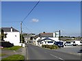
1
Antron Hill approaches junction with Gweal Darras
Image: © Stuart Logan
Taken: 8 Oct 2012
0.12 miles
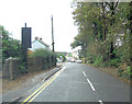
2
Gweal Darras, Mabe Burnthouse
A road leading to a development of 20th century houses
Image: © David Smith
Taken: 30 Sep 2015
0.12 miles
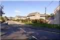
4
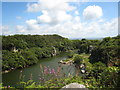
Flooded quarry at Carnsew near Mabe
This is just a small corner of Carnsew Quarry which is still active. Carnsew is Cornwall's largest inland quarry. Based on the edge of the Carnmenellis Granite intrusion, a silver grey granite is produced in a full range of sizes, providing crusher run, scalpings of various sizes, gabion stone and rock armour. The quarry contains stone coating and ready mix plants supplying the local markets. Aram has shipped aggregates and armour stone from this quarry via the nearby Port of Falmouth and Carnsew Granite has been used in several rock armour projects along the south coast.
Image: © Rod Allday
Taken: 5 Jun 2008
0.15 miles
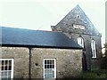
5
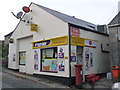
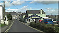
Mabe Burnthouse: the post office
The village store and post office is just to the west of the main crossroads in the village. There has been a post office in Mabe Burnthouse since 1897.
Image: © Chris Downer
Taken: 15 Oct 2013
0.17 miles
6
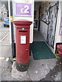
Mabe Burnthouse: postbox № TR10 57
This Elizabeth II-reign postbox stands outside the door of Image and receives its final collections at 4pm on weekdays and at 10:45am on Saturdays.
Image: © Chris Downer
Taken: 15 Oct 2013
0.17 miles
7
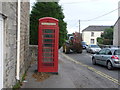
Mabe Burnthouse: red phone box
This traditional 'K6' phone box is viewed from outside the door of Image
Image: © Chris Downer
Taken: 15 Oct 2013
0.18 miles
9
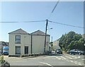
Former Toll House, Antron Hill
In the Mabe Burnthouse, Penryn district of Falmouth at the junction of Antron Hill and Church Road.
It served the Helston Turnpike Trust in the 19ᵗʰ C.
Milestone Society National ID: CW.MAB
Image: © Paul Barnett
Taken: 4 Jun 2023
0.21 miles