IMAGES TAKEN NEAR TO
Carnsew Close, PENRYN, TR10 9HE
Introduction
This page details the photographs taken nearby to Carnsew Close, TR10 9HE by members of the Geograph project.
The Geograph project started in 2005 with the aim of publishing, organising and preserving representative images for every square kilometre of Great Britain, Ireland and the Isle of Man.

There are currently over 7.5m images from over14,400 individuals and you can help contribute to the project by visiting https://www.geograph.org.uk
Image Map
Images are licensed for reuse under creativecommons.org/licenses/by-sa/2.0
Notes
- Clicking on the map will re-center to the selected point.
- The higher the marker number, the further away the image location is from the centre of the postcode.
Image Listing (17 Images Found)
Images are licensed for reuse under creativecommons.org/licenses/by-sa/2.0
Image
Details
Distance
1
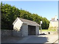
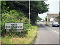
Bus shelter, Treliever Road, Mabe Burnthouse
Image: © David Smith
Taken: 30 Sep 2015
0.12 miles
2
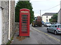
Mabe Burnthouse: red phone box
This traditional 'K6' phone box is viewed from outside the door of Image
Image: © Chris Downer
Taken: 15 Oct 2013
0.13 miles
3
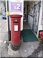
Mabe Burnthouse: postbox № TR10 57
This Elizabeth II-reign postbox stands outside the door of Image and receives its final collections at 4pm on weekdays and at 10:45am on Saturdays.
Image: © Chris Downer
Taken: 15 Oct 2013
0.13 miles
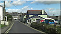
4
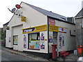
Mabe Burnthouse: the post office
The village store and post office is just to the west of the main crossroads in the village. There has been a post office in Mabe Burnthouse since 1897.
Image: © Chris Downer
Taken: 15 Oct 2013
0.13 miles
5
Former Toll House, Antron Hill
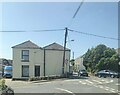
In the Mabe Burnthouse, Penryn district of Falmouth at the junction of Antron Hill and Church Road.
It served the Helston Turnpike Trust in the 19ᵗʰ C.
Milestone Society National ID: CW.MAB
Image: © Paul Barnett
Taken: 4 Jun 2023
0.13 miles
6
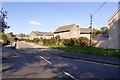
Gweal Darras, Mabe Burnthouse
A road leading to a development of 20th century houses
Image: © David Smith
Taken: 30 Sep 2015
0.14 miles
8
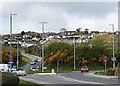
Mabe Burnthouse
The title above is the name of this suburban settlement. This shot looks uphill from the roundabout on the main road to the east of the village.
Image: © Tony Atkin
Taken: 1 May 2006
0.14 miles
10
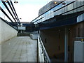
University of Exeter in Cornwall, Tremough Campus
The Tremough Campus encompasses a series of buildings enclosing 'courtyards' - this image showing the walkway that runs easterly between the northern and southern teaching blocks, culminating at the entrance to the Learning Resources Centre.
Image: © Gwyn Jones
Taken: 5 Dec 2005
0.15 miles