IMAGES TAKEN NEAR TO
Burnthouse, PENRYN, TR10 9AS
Introduction
This page details the photographs taken nearby to Burnthouse, TR10 9AS by members of the Geograph project.
The Geograph project started in 2005 with the aim of publishing, organising and preserving representative images for every square kilometre of Great Britain, Ireland and the Isle of Man.

There are currently over 7.5m images from over14,400 individuals and you can help contribute to the project by visiting https://www.geograph.org.uk
Image Map
Images are licensed for reuse under creativecommons.org/licenses/by-sa/2.0
Notes
- Clicking on the map will re-center to the selected point.
- The higher the marker number, the further away the image location is from the centre of the postcode.
Image Listing (12 Images Found)
Images are licensed for reuse under creativecommons.org/licenses/by-sa/2.0
Image
Details
Distance
1
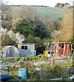
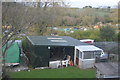
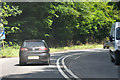
Cornwall : Country Lane
A small lane off of the A393.
Image: © Lewis Clarke
Taken: 13 Jul 2015
0.04 miles
3
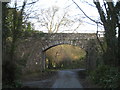
Railway bridge at Burnthouse
Carrying the Falmouth-Truro line over a very minor road.
Image: © Rod Allday
Taken: 18 Nov 2008
0.10 miles
5

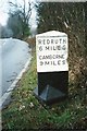
Old Milestone by the A393, south of Burnthouse
Carved stone post by the A393, in parish of ST GLUVIAS (KERRIER District), climb South out of Burnthouse, by the road, on East side of road. Penryn marker, erected by the County Council in the 19th century.
Inscription reads:-
: PENRYN / 2 MILES / FALMOUTH / 4 MILES : : REDRUTH / 6 MILES / CAMBORNE / 9 MILES :
Grade II listed.
List Entry Number: 1328126 https://historicengland.org.uk/listing/the-list/list-entry/1328126
Milestone Society National ID: CW_PNRR02.
Image: © Rosy Hanns
Taken: 4 May 2019
0.12 miles
6
Old Milestone by the A393, south of Burnthouse
Carved stone post by the A393, in parish of ST GLUVIAS (KERRIER District), climb South out of Burnthouse, by the road, on East side of road. Penryn marker, erected by the County Council in the 19th century.
Inscription reads:-
: PENRYN / 2 MILES / FALMOUTH / 4 MILES : : REDRUTH / 6 MILES / CAMBORNE / 9 MILES :
Grade II Listed. List Entry Number: 1328126
https://historicengland.org.uk/listing/the-list/list-entry/1328126
Milestone Society National ID: CW_PNRR02.
Image: © Ian Thompson
Taken: 10 Dec 2017
0.12 miles
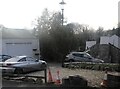
8
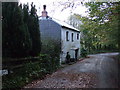
Former St Gluvias Tollhouse, Lower Treluswell
Tollhouse by the unclassified road (was A39), in the parish of St. Gluvias (Kerrier District), Turnpike Cottage, The Barns, Lower Treluswell, TR10 9AT.
Cornwall & Scilly HER.
HER Number: 176751 https://www.heritagegateway.org.uk/Gateway/Results_Single.aspx?uid=MCO52560&resourceID=1020
Surveyed
Milestone Society National ID: CW.SGL
Image: © Alan Rosevear
Taken: 26 Feb 2009
0.16 miles
9
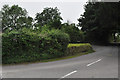
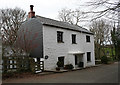
Cornwall : The A39
The A39 heads through Cornwall.
Image: © Lewis Clarke
Taken: 17 Jul 2015
0.17 miles