IMAGES TAKEN NEAR TO
Truro Hill, PENRYN, TR10 8DB
Introduction
This page details the photographs taken nearby to Truro Hill, TR10 8DB by members of the Geograph project.
The Geograph project started in 2005 with the aim of publishing, organising and preserving representative images for every square kilometre of Great Britain, Ireland and the Isle of Man.

There are currently over 7.5m images from over14,400 individuals and you can help contribute to the project by visiting https://www.geograph.org.uk
Image Map
Images are licensed for reuse under creativecommons.org/licenses/by-sa/2.0
Notes
- Clicking on the map will re-center to the selected point.
- The higher the marker number, the further away the image location is from the centre of the postcode.
Image Listing (65 Images Found)
Images are licensed for reuse under creativecommons.org/licenses/by-sa/2.0
Image
Details
Distance
1
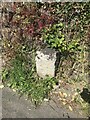
Old Boundary Marker on Truro Hill, St Gluvias
Boundary Marker on the east side of Truro Hill, St Gluvias, in front of no.30. Penryn parish. Inscribed E.
Milestone Society National ID: CW_PENRYN03bm
Image: © P Barnett
Taken: 11 Jun 2024
0.01 miles
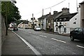
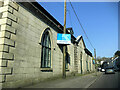
6
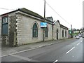
Former National Schools, Penrhyn
The building is inscribed "1837 / National Schools" on the pediment over the door.
It is now the Highway Community Centre.
Image: © Humphrey Bolton
Taken: 6 Jan 2016
0.09 miles
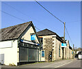
7
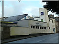
Commercial Laundry
I'm sure this used to be Penryn Steam Laundry or similar but is now Berendsen. This block has a nod to art deco cinema architecture but the steamy goings on are of a different nature.
Image: © Chris Allen
Taken: 23 Apr 2014
0.15 miles
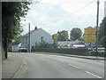
9
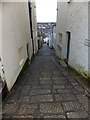
Truro Lane, Penryn
A steep descent from the main road through Penryn. The stones are grooved to help protect users from slipping (but beyond the extent of these stones, you take responsibility for your own balance!)
Image: © David Smith
Taken: 22 Mar 2013
0.17 miles