IMAGES TAKEN NEAR TO
Bridgeside, TOTNES, TQ9 7UH
Introduction
This page details the photographs taken nearby to Bridgeside, TQ9 7UH by members of the Geograph project.
The Geograph project started in 2005 with the aim of publishing, organising and preserving representative images for every square kilometre of Great Britain, Ireland and the Isle of Man.

There are currently over 7.5m images from over14,400 individuals and you can help contribute to the project by visiting https://www.geograph.org.uk
Image Map (Loading...)


Getting Data...Please wait
Leaflet Map data © OpenStreetMap
Images are licensed for reuse under creativecommons.org/licenses/by-sa/2.0
Notes
- Clicking on the map will re-center to the selected point.
- The higher the marker number, the further away the image location is from the centre of the postcode.
Image Listing (55 Images Found)
Images are licensed for reuse under creativecommons.org/licenses/by-sa/2.0
Image
Details
Distance
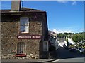
1

Public House, Harbertonford
The Maltsters Arms in Harbertonford.
Image: © Wayland Smith
Taken: 4 Oct 2014
0.01 miles
2
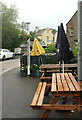
Unused picnic tables, Harbertonford
Hardly surprising on a dismal Sunday. The signpost seems to have migrated across the A381 since Image was taken.
Image: © Derek Harper
Taken: 12 Aug 2018
0.01 miles
3
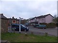
Church Green at the centre of Harbertonford
Image: © David Smith
Taken: 20 Feb 2013
0.01 miles
4
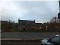
The Old School House, Harbertonford
Now a private house offering bed and breakfast in the centre of the village
Image: © David Smith
Taken: 20 Feb 2013
0.01 miles
5
Harbertonford : Maltsters Arms & Old Road
Winifred Marsden ran this pub for 30 years, things have not changed a great deal over the past 17 years and it's still a proper little country pub.
Image: © Lewis Clarke
Taken: 24 Jul 2007
0.01 miles
6
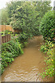
Harbourne River, Harbertonford
Looking upstream from Harbertonford Bridge. The river is very muddy after rain.
Image: © Derek Harper
Taken: 12 Aug 2018
0.01 miles
7
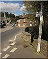
A381 at Harbertonford
A similar view to Image, again with the bridge over the Harbourne http://www.britishlistedbuildings.co.uk/en-101331-harbertonford-bridge-harberton-devon and the Maltsters Arms http://www.britishlistedbuildings.co.uk/en-101332-floyd-s-inn-harberton-devon . St Peter's church is described at http://www.britishlistedbuildings.co.uk/en-101335-church-of-st-peter-harberton-devon .
Image: © Derek Harper
Taken: 19 Sep 2012
0.02 miles
9
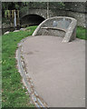
Slate seat and edge to paving, Harbertonford
This is a detail of the village green landscaping seen in Image It was constructed as part of the Harbertonford Flood Defence Scheme. Its completion is recorded on a narrow crescent-shaped strip of bronze set into the slate edging, left. The relief inscription, all in lower case, reads: "harbertonford flood defence scheme opened by sir john harman, chairman, environment agency, on 15th may 2003".
The village green is seen in the foreground of Image More details of the scheme are linked from Image
Image: © Robin Stott
Taken: 29 Jul 2010
0.02 miles
10
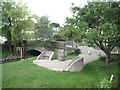
Village green, Harbertonford
The little landscaped feature consists of seats, paving and an information panel, mostly constructed of local slate, as part of the Harbertonford Flood Defence Scheme completed in 2003. A detail is at Image Note the stone facing to the banks of the Harbourne River, and the flood gauge. The stream is the subject of Image
The village green is seen in the foreground of Image More details of the scheme are linked from Image
Image: © Robin Stott
Taken: 29 Jul 2010
0.02 miles