IMAGES TAKEN NEAR TO
East Allington, TOTNES, TQ9 7RL
Introduction
This page details the photographs taken nearby to TQ9 7RL by members of the Geograph project.
The Geograph project started in 2005 with the aim of publishing, organising and preserving representative images for every square kilometre of Great Britain, Ireland and the Isle of Man.

There are currently over 7.5m images from over14,400 individuals and you can help contribute to the project by visiting https://www.geograph.org.uk
Image Map
Images are licensed for reuse under creativecommons.org/licenses/by-sa/2.0
Notes
- Clicking on the map will re-center to the selected point.
- The higher the marker number, the further away the image location is from the centre of the postcode.
Image Listing (7 Images Found)
Images are licensed for reuse under creativecommons.org/licenses/by-sa/2.0
Image
Details
Distance
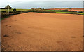
1
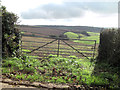
Arable & pasture land. northwest of Lower Norton
Image: © Stuart Logan
Taken: 8 Oct 2013
0.08 miles
2
Farmland, Higher Norton Farm
Looking right from where Image was taken, with overlap, and a somewhat zen-like group of stones in the foreground.
Image: © Derek Harper
Taken: 25 Oct 2018
0.12 miles
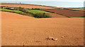
3
Field, Lower Norton
Looking right from Image], with a glimpse of Lower Norton in the valley; on the right is the hedge beside the track down to the farm, and other group of stones
Image: © Derek Harper
Taken: 25 Oct 2018
0.15 miles
4
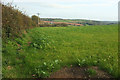
Field by NCN28
On the left is a hedge bordering the track to lower Norton; the corresponding hedge on the north side of the track is on the right of Image The most conspicuous barns, though, are at Colehanger Farm.
Image: © Derek Harper
Taken: 25 Oct 2018
0.15 miles
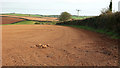
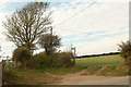
5
Field near Higher Norton Farm
The lane on the left carries NCN28.
Image: © Derek Harper
Taken: 25 Oct 2018
0.22 miles
6
Green lane to Cross Farm
Looking behind the camera in Image The green lane, signed as an unmetalled road, is a route with public access.
Image: © Derek Harper
Taken: 25 Oct 2018
0.23 miles
7
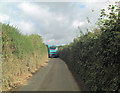
What are we going to do now?
The answer is always the same on these narrow Devon lanes. The smaller vehicle, or more polite driver, reverses to the nearest farm gateway; which in this case is Cole's Cross to the southwest.
Image: © Stuart Logan
Taken: 8 Oct 2013
0.23 miles