IMAGES TAKEN NEAR TO
Laburnum Way, TOTNES, TQ9 7QY
Introduction
This page details the photographs taken nearby to Laburnum Way, TQ9 7QY by members of the Geograph project.
The Geograph project started in 2005 with the aim of publishing, organising and preserving representative images for every square kilometre of Great Britain, Ireland and the Isle of Man.

There are currently over 7.5m images from over14,400 individuals and you can help contribute to the project by visiting https://www.geograph.org.uk
Image Map
Images are licensed for reuse under creativecommons.org/licenses/by-sa/2.0
Notes
- Clicking on the map will re-center to the selected point.
- The higher the marker number, the further away the image location is from the centre of the postcode.
Image Listing (47 Images Found)
Images are licensed for reuse under creativecommons.org/licenses/by-sa/2.0
Image
Details
Distance
1
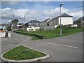
Laburnum Way and car park
Dartmouth Road in the distance; Lister Way on the right.
Image: © Robin Stott
Taken: 2 Apr 2011
0.01 miles
2
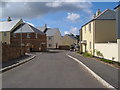
Lister Way, East Allington
This new greenfield development on the edge of the village offers 38 flats and houses for rent and shared ownership to people with significant local connections http://www2.powerlounge.co.uk/EditSite/Customers/694/nz-docs/Briefing%20sheet-East%20Allington-SHDC%20approved.pdf .
Image: © Derek Harper
Taken: 28 Jul 2006
0.02 miles
3
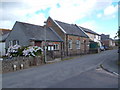
East Allington Parish Hall
Seen from across the main village street.
Image: © Derek Harper
Taken: 28 Jul 2006
0.03 miles
4
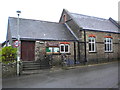
East Allington Parish Hall
Situated on the main street through the village.
Image: © jeff collins
Taken: 6 Nov 2013
0.04 miles
5
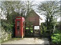
Telephone kiosk and exchange, Dartmouth Road
Image: © Robin Stott
Taken: 2 Apr 2011
0.04 miles
6
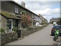
Cottages, Vineyard Terrace
Sheltered parts of the South Hams are almost sub-tropical. Here is a Camellia in flower beside a Cordyline.
Image: © Robin Stott
Taken: 2 Apr 2011
0.04 miles
7
Site of shop, East Allington
Until 2000, this was the village shop and post office, now demolished, with plans for dwellings to be built on the site. It means that villagers must travel 4 miles to Kingsbridge to shop.
Image: © Derek Harper
Taken: 28 Jul 2006
0.05 miles
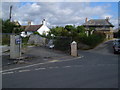
8
Bus stop, Efford Corner
Postbox number TQ9 102; Dartmouth Road goes up the hill.
Image: © Robin Stott
Taken: 2 Apr 2011
0.05 miles
9

Rendered!
A house in Dartmouth Road, a characteristic South Hams grey.
Image: © Robin Stott
Taken: 2 Apr 2011
0.05 miles
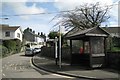
10
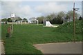
Village recreation ground
Across the Dartmouth Road from the football pitch there is a fenced playspace for young children, a kickabout, a skate ramp and a netball or basketball court: hard to say which.
Image: © Robin Stott
Taken: 2 Apr 2011
0.05 miles