IMAGES TAKEN NEAR TO
Diptford, TOTNES, TQ9 7PF
Introduction
This page details the photographs taken nearby to TQ9 7PF by members of the Geograph project.
The Geograph project started in 2005 with the aim of publishing, organising and preserving representative images for every square kilometre of Great Britain, Ireland and the Isle of Man.

There are currently over 7.5m images from over14,400 individuals and you can help contribute to the project by visiting https://www.geograph.org.uk
Image Map (Loading...)


Getting Data...Please wait
Leaflet Map data © OpenStreetMap
Images are licensed for reuse under creativecommons.org/licenses/by-sa/2.0
Notes
- Clicking on the map will re-center to the selected point.
- The higher the marker number, the further away the image location is from the centre of the postcode.
Image Listing (14 Images Found)
Images are licensed for reuse under creativecommons.org/licenses/by-sa/2.0
Image
Details
Distance
1
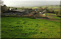
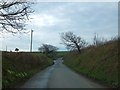
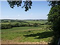
Lower Kerswill Farm
The view taken in 2009 at Image shows a rough track crossing this field to the farm, but it seems to have fallen out of use during the intervening decade. The moor looms in the distance.
Image: © Derek Harper
Taken: 26 Nov 2019
0.04 miles
2
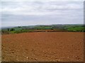
Devon's red earth
A common soil colour in this area - red earth makes green grass.
Image: © Richard Knights
Taken: 7 May 2006
0.05 miles
3
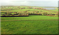
Countryside north of Kerswill
Image: © Derek Harper
Taken: 26 Nov 2019
0.06 miles
4
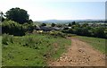
Lower Kerswill
Farm buildings seen from the lane from Lincombe Farm. The spot gives a good view across this part of the South Hams towards southern Dartmoor.
Image: © Derek Harper
Taken: 24 Jun 2009
0.07 miles
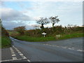
5
Kerswill Cross
Approaching the crossroads from the north; primroses have become established on the banks
Image: © David Smith
Taken: 29 Mar 2014
0.10 miles
7
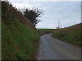
Deep banks by the road near Kerswill Cross
Use of the road has worn a cutting through the hillside
Image: © David Smith
Taken: 29 Mar 2014
0.11 miles
8
Field near Kerswill
The view on the right-hand side of the hedge in Image; the same ash tree can be seen. The wood in the middle distance is Kerswill Copse.
Image: © Derek Harper
Taken: 24 Jun 2009
0.14 miles
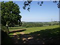
9
Countryside at Kerswill
From the same spot as Image, looking to the right towards the shallow upper valley of a tributary of the Harbourne River.
Image: © Derek Harper
Taken: 24 Jun 2009
0.14 miles
10
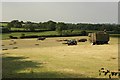
Harvesting grass, Kerswill Cross
It's a sunny evening but poor weather is forecast, so this farmer is taking advantage of the long midsummer day to get in a crop of grass.
Image: © Derek Harper
Taken: 24 Jun 2009
0.19 miles