IMAGES TAKEN NEAR TO
Tuckenhay, TOTNES, TQ9 7HR
Introduction
This page details the photographs taken nearby to TQ9 7HR by members of the Geograph project.
The Geograph project started in 2005 with the aim of publishing, organising and preserving representative images for every square kilometre of Great Britain, Ireland and the Isle of Man.

There are currently over 7.5m images from over14,400 individuals and you can help contribute to the project by visiting https://www.geograph.org.uk
Image Map
Images are licensed for reuse under creativecommons.org/licenses/by-sa/2.0
Notes
- Clicking on the map will re-center to the selected point.
- The higher the marker number, the further away the image location is from the centre of the postcode.
Image Listing (12 Images Found)
Images are licensed for reuse under creativecommons.org/licenses/by-sa/2.0
Image
Details
Distance
1
Entrance to Dart Vale Fish Farm
An aerial photo shows many ponds of different sizes alongside the River Wash. A large scale map says Trout Farm.
Image: © Robin Stott
Taken: 19 Jul 2011
0.01 miles
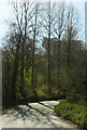
2
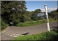
Millpond Cross
The junction and signpost seen in Image from a different direction. As the signpost indicates, a National Cycle Network route passes this way; NCN2, in this case.
Image: © Derek Harper
Taken: 19 Sep 2012
0.15 miles
3
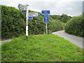
Millpond Cross
The lanes from Cornworthy and Tuckenhay join and continue to Washbourne. The Explorer map shows open water/marsh to the north (right) on either side of the lane to Tuckenhay. A leat heads in the direction of the former Tuckenhay paper mill. Some ponds remain, conceivably now associated with the fish farm to the west. The scene is pictured from a different viewpoint in Image
Image: © Robin Stott
Taken: 19 Jul 2011
0.15 miles
4
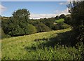
Field by Millpond Cross
From the gate on the right in the background of Image The field is on the southern slopes of the Wash valley where it meets the Gitcombe valley. On the right is Edgecombe Barn, a holiday let.
Image: © Derek Harper
Taken: 19 Sep 2012
0.20 miles
5
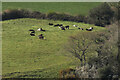
Cattle above the Wash valley
A detail of Image], with a few terracettes where the field steepens.
Image: © Derek Harper
Taken: 22 Apr 2021
0.22 miles
6
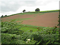
Patchy germination
Three boundaries have been removed to form this one field on the north side of the valley of the river Wash. The view is from the lane to Lower Washbourne from Tuckenhay and Cornworthy. The lop-sided tree on the skyline, left of centre, is also seen in Image
Image: © Robin Stott
Taken: 19 Jul 2011
0.23 miles
7
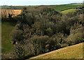
Wood, Coomery
A detail of Image], centring on the wood across the valley.
Image: © Derek Harper
Taken: 22 Apr 2021
0.23 miles

9
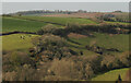
Countryside, Wash valley
A detail of the scene in Image
Image: © Derek Harper
Taken: 22 Apr 2021
0.23 miles
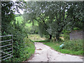
10
Laneside trees, Small Bridge
This bend takes the lane from Cornworthy across Small Bridge and a tributary of the River Wash. Image] looks left from here.
Image: © Derek Harper
Taken: 22 Apr 2021
0.24 miles