IMAGES TAKEN NEAR TO
TQ9 7FU
Introduction
This page details the photographs taken nearby to TQ9 7FU by members of the Geograph project.
The Geograph project started in 2005 with the aim of publishing, organising and preserving representative images for every square kilometre of Great Britain, Ireland and the Isle of Man.

There are currently over 7.5m images from over14,400 individuals and you can help contribute to the project by visiting https://www.geograph.org.uk
Image Map
Images are licensed for reuse under creativecommons.org/licenses/by-sa/2.0
Notes
- Clicking on the map will re-center to the selected point.
- The higher the marker number, the further away the image location is from the centre of the postcode.
Image Listing (31 Images Found)
Images are licensed for reuse under creativecommons.org/licenses/by-sa/2.0
Image
Details
Distance
1

Footpath to Tuckenhay from Cornworthy Cross
One of several footpaths which climb from the east side of the stream at Tuckenhay to the road on Corkscrew Hill
Image: © David Smith
Taken: 26 Dec 2013
0.12 miles
2
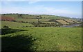
Field by Hothill Lane
The field is on the north side of Corkscrew Hill, and gives a view over Bow Creek.
Image: © Derek Harper
Taken: 27 Sep 2009
0.12 miles
3
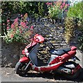
Motor scooter, red and dead, Abbey Road, Cornworthy
Image: © Robin Stott
Taken: 5 Jul 2013
0.12 miles
4
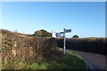
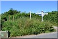
Signpost and Abbey Cross junction
The arms on the signpost are in different styles. Presumably one needed to be replaced, and it was not economic to replace all three arms?
Image: © David Smith
Taken: 26 Dec 2013
0.12 miles
5
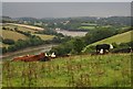
Cattle on Corkscrew Hill
Seen from Hothill Lane. Behind them is a view down Bow Creek to the Dart at Duncannon Reach.
Image: © Derek Harper
Taken: 25 Aug 2013
0.12 miles
6
Cornworthy Cross
A T-junction now but at one time this was a crossroads. The fourth road is today an unmetalled county road, announced by the green sign, north to Tuckenhay.
Image: © Robin Stott
Taken: 5 Jul 2013
0.13 miles
7
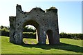
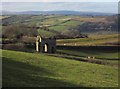
The Priory Gatehouse, above Cornworthy
The Gatehouse of c.1400 is all that remains standing of a "priory of Augustinian nuns founded early in the C13..." (Pevsner, South Devon, Penguin 1952).
There is a kissing gate out on to the road, obscured by the gatehouse. All this grassy open space stretching down to the village, seems to be in the care of the parish council. Note the public seat, right.
Image: © Robin Stott
Taken: 5 Jul 2013
0.14 miles
8
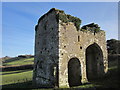
Priory Gatehouse, Cornworthy
The grade I listed gatehouse http://list.english-heritage.org.uk/resultsingle.aspx?uid=1291588&searchtype=mapsearch is all that remains (above ground) of an Augustinian priory. "Cornworthy Priory was the most westerly and isolated of the houses founded specifically for nuns in England" http://list.english-heritage.org.uk /resultsingle.aspx?uid=1008673&searchtype=mapsearch " The main southern passage for mounted travellers and wheeled vehicles has a tunnel vault ... the smaller pedestrian passage has a ribbed vault" . See also Image, taken from the other side.
Image: © Derek Harper
Taken: 17 Feb 2015
0.14 miles
9
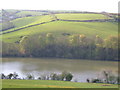
Bow Creek
Seen from the footpath that descends to the creek from Ashprington. Up the far hill on the left is Cornworthy.
Image: © Derek Harper
Taken: 29 Apr 2006
0.14 miles
10
Priory Gatehouse, Cornworthy
Image: © Derek Harper
Taken: 17 Feb 2015
0.14 miles