IMAGES TAKEN NEAR TO
Christina Parade, TOTNES, TQ9 5UU
Introduction
This page details the photographs taken nearby to Christina Parade, TQ9 5UU by members of the Geograph project.
The Geograph project started in 2005 with the aim of publishing, organising and preserving representative images for every square kilometre of Great Britain, Ireland and the Isle of Man.

There are currently over 7.5m images from over14,400 individuals and you can help contribute to the project by visiting https://www.geograph.org.uk
Image Map
Images are licensed for reuse under creativecommons.org/licenses/by-sa/2.0
Notes
- Clicking on the map will re-center to the selected point.
- The higher the marker number, the further away the image location is from the centre of the postcode.
Image Listing (45 Images Found)
Images are licensed for reuse under creativecommons.org/licenses/by-sa/2.0
Image
Details
Distance
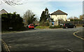
1
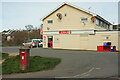
Supermarket, Bridgetown
Seen across Weston Lane. The Elizabeth II postbox is TQ9 121 and is shown in close-up at Image
Image: © Derek Harper
Taken: 17 Mar 2021
0.01 miles
2
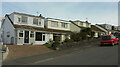
Houses and shop, Weston Lane
On the left is a Spar supermarket.
Image: © Derek Harper
Taken: 17 Mar 2021
0.02 miles
3
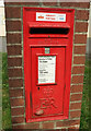
Postbox, Weston Lane
Elizabeth II postbox TQ9 121 is shown in context at Image
Image: © Derek Harper
Taken: 17 Mar 2021
0.02 miles
4
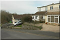
Weston Lane
Dropping ever more steeply to the junction with Parkers Way. On the right is the Spar supermarket.
Image: © Derek Harper
Taken: 17 Mar 2021
0.03 miles
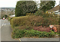
5
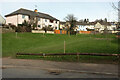
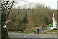
Green space by Weston Lane
Glimpsed in Image], and occupying a small valley between estates.
Image: © Derek Harper
Taken: 17 Mar 2021
0.03 miles
6
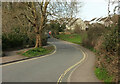
Weston Lane, Totnes
At the junction with Culverdale. The road crosses a small stream by the green space ahead.
Image: © Derek Harper
Taken: 17 Mar 2021
0.03 miles
7
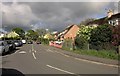
Houses on Weston Lane
A steep climb out of town on the suburban road.
Image: © Derek Harper
Taken: 17 Mar 2021
0.06 miles
8
Westonfields, Bridgetown
Double-decker buses ply this residential route - two per hour in each direction. Taken an hour after Image] - and over five miles away. A lovely late afternoon after an awful early one.
Image: © Derek Harper
Taken: 1 May 2014
0.11 miles
9
Crossroads, Bridgetown
Weston Lane gives way as it crosses Pathfields (left) / Westonfields (right) and becomes a one-way street with access only for vehicles.
Image: © Derek Harper
Taken: 17 Mar 2021
0.11 miles
10
Red Panda on Weston Lane
Part of Malcolm Curley's Bridgetown Safari.
Image: © Derek Harper
Taken: 17 Mar 2021
0.12 miles