IMAGES TAKEN NEAR TO
Blackpost Lane, TOTNES, TQ9 5RF
Introduction
This page details the photographs taken nearby to Blackpost Lane, TQ9 5RF by members of the Geograph project.
The Geograph project started in 2005 with the aim of publishing, organising and preserving representative images for every square kilometre of Great Britain, Ireland and the Isle of Man.

There are currently over 7.5m images from over14,400 individuals and you can help contribute to the project by visiting https://www.geograph.org.uk
Image Map
Images are licensed for reuse under creativecommons.org/licenses/by-sa/2.0
Notes
- Clicking on the map will re-center to the selected point.
- The higher the marker number, the further away the image location is from the centre of the postcode.
Image Listing (67 Images Found)
Images are licensed for reuse under creativecommons.org/licenses/by-sa/2.0
Image
Details
Distance
1
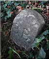
Old Boundary Marker by the A385, Bridgetown Hill, Totnes
Parish Boundary Marker by the A385, in parish of Totnes (South Hams District), Bridgetown Hill, on grass verge.
Devon & Dartmoor HER.
HER Number: MDV43483 https://www.heritagegateway.org.uk/Gateway/Results_Single.aspx?uid=MDV43483&resourceID=104
Surveyed
Milestone Society National ID: DV_TOT03pb
Image: © Milestone Society
Taken: Unknown
0.04 miles
2

Bridgetown - Totnes
A view of the Bridgetown area of Totnes.
Image: © Richard Knights
Taken: 20 Aug 2005
0.04 miles
3
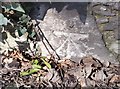
Ordnance Survey Cut Mark
This OS cut mark can be found on the wall of Highlands, Bridgetown Hill. It marks a point 68.051m above mean sea level.
Image: © Adrian Dust
Taken: 25 Mar 2019
0.05 miles
4
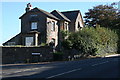
House at Blackpost Cross
This is the last house in Totnes Bridgetown at the top of the hill on the road to the east.
Image: © Tony Atkin
Taken: 18 Oct 2008
0.05 miles
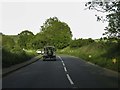
6
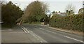
Blackpost Cross
The A385 begins its descent of Bridgetown Hill here, passing the junction with Blackpost Lane in the foreground, and Jubilee Road on the right.
Image: © Derek Harper
Taken: 17 Mar 2021
0.06 miles
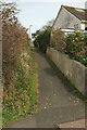
7
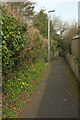
Path approaching Bridgetown Hill
The footpath shown in Image] is approaching the A385 close to Blackpost Cross.
Image: © Derek Harper
Taken: 17 Mar 2021
0.06 miles
8
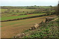
Farmland by the A385
A large tree has been felled.
Image: © Derek Harper
Taken: 17 Mar 2021
0.06 miles
9
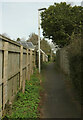
Footpath to Blackpost Cross
Further along the path shown in Image
Image: © Derek Harper
Taken: 17 Mar 2021
0.06 miles
10
Footpath from Higher Westonfields
Leading to the A385 at Blackpost Cross.
Image: © Derek Harper
Taken: 17 Mar 2021
0.07 miles