IMAGES TAKEN NEAR TO
Antrim Terrace, TOTNES, TQ9 5QA
Introduction
This page details the photographs taken nearby to Antrim Terrace, TQ9 5QA by members of the Geograph project.
The Geograph project started in 2005 with the aim of publishing, organising and preserving representative images for every square kilometre of Great Britain, Ireland and the Isle of Man.

There are currently over 7.5m images from over14,400 individuals and you can help contribute to the project by visiting https://www.geograph.org.uk
Image Map
Images are licensed for reuse under creativecommons.org/licenses/by-sa/2.0
Notes
- Clicking on the map will re-center to the selected point.
- The higher the marker number, the further away the image location is from the centre of the postcode.
Image Listing (777 Images Found)
Images are licensed for reuse under creativecommons.org/licenses/by-sa/2.0
Image
Details
Distance
1
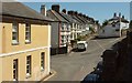
Junction, Totnes
Below left is Lower Collins Road; in the centre is Antrim Terrace, and heading off to the right is Castle Street. On the left is the former Globe Inn, celebrated by the local band Pale Blue Eyes.
Image: © Derek Harper
Taken: 23 Aug 2016
0.02 miles
2
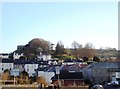
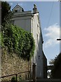
Totnes Castle
Totnes Castle sits above the town on its ramparts in a dominant position.
Image: © Tom Jolliffe
Taken: 22 Mar 2010
0.03 miles
3
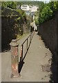
Path, Northgate, Totnes
On a direct route from the top of the town centre to the station, this path avoids the narrow Castle Street for those on foot.
Image: © Derek Harper
Taken: 23 Aug 2016
0.04 miles
4
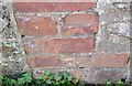
Ordnance Survey Cut Mark
This OS cut mark can be found on the building west side of Castle Street. It marks a point 7.587m above mean sea level.
Image: © Adrian Dust
Taken: 25 Mar 2019
0.04 miles
5

Ordnance Survey Cut Mark
This OS cut mark can be found on the wall west side of the footpath. It marks a point 19.330m above mean sea level.
Image: © Adrian Dust
Taken: 25 Mar 2019
0.04 miles
6
Northgate Lodge, Totnes
The west side of an "early c19 villa" https://www.historicengland.org.uk/listing/the-list/list-entry/1107466 also shown in Image, seen from the path shown in Image (which shows the same railings and metal post).
Image: © Derek Harper
Taken: 26 Aug 2017
0.04 miles
7
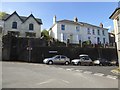
Castle View Terrace, Totnes
The castle is to be viewed from the rear of these houses, not from the road
Image: © David Smith
Taken: 27 Apr 2017
0.05 miles
8
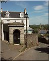
Northgate Lodge, Totnes
Between Castle Street (right) and the path shown in Image], this "early C19 villa" is described at https://www.historicengland.org.uk/listing/the-list/list-entry/1107466 . The impressive garden entrance consists of "round-arched gateway with rusticated voussoirs and surround, cornice and blocking course; double panelled doors with Greek fret decoration".
Image: © Derek Harper
Taken: 23 Aug 2016
0.05 miles
9
Castle View Terrace
These elevated properties have a fine view.
Image: © Michael Dibb
Taken: 31 May 2017
0.05 miles
10
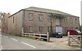
Warehouse, Castle Street, Totnes
A nineteenth century within the Totnes conservation area, and close to the listed warehouses shown in Image
Image: © Derek Harper
Taken: 24 Feb 2011
0.05 miles