IMAGES TAKEN NEAR TO
Ford Road, TOTNES, TQ9 5LQ
Introduction
This page details the photographs taken nearby to Ford Road, TQ9 5LQ by members of the Geograph project.
The Geograph project started in 2005 with the aim of publishing, organising and preserving representative images for every square kilometre of Great Britain, Ireland and the Isle of Man.

There are currently over 7.5m images from over14,400 individuals and you can help contribute to the project by visiting https://www.geograph.org.uk
Image Map
Images are licensed for reuse under creativecommons.org/licenses/by-sa/2.0
Notes
- Clicking on the map will re-center to the selected point.
- The higher the marker number, the further away the image location is from the centre of the postcode.
Image Listing (347 Images Found)
Images are licensed for reuse under creativecommons.org/licenses/by-sa/2.0
Image
Details
Distance
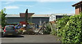
1
Parragon Building, Totnes Industrial Estate
An education centre; in fact, a special school for pupils aged 11-19.
Image: © Derek Harper
Taken: 23 Aug 2016
0.01 miles
2
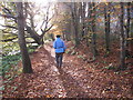
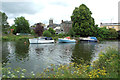
Walking by the River Dart in autumn, Totnes
For a winter view at the same place see Image .
Image: © David Hawgood
Taken: 18 Nov 2017
0.02 miles
3
Twigs above the Dart
Beech twigs by the riverside path north of Brutus Bridge.
Image: © Derek Harper
Taken: 5 Jan 2022
0.03 miles
4
Builder's yard, Totnes
Seen past a fence, and on the Totnes Industrial Estate.
Image: © Derek Harper
Taken: 23 Aug 2016
0.03 miles
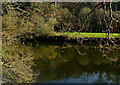
5
The River Dart
An attractive scene viewed on a disappointingly dull afternoon at the end of June.
Image: © Mary and Angus Hogg
Taken: 30 Jun 2016
0.03 miles
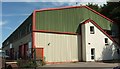
6

Brandon Tool Hire, Totnes
Occupying part of The Stables on Ford Road on the Totnes Industrial Estate. "This week, we are mostly dealing in the hire of portable loos". Well, it is still the festival season.
Image: © Derek Harper
Taken: 23 Aug 2016
0.03 miles
8
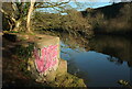
Graffiti by the Dart
Beside Totnes footpath 17 above Brutus Bridge.
Image: © Derek Harper
Taken: 5 Jan 2022
0.04 miles
9
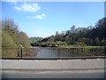
Path by the Dart, Totnes
This is just above the main road bridge, Brutus Bridge. The path is shown on the 1:25,000 map as a public footpath beside the Dart as far as the weir which diverted water into the Mill Leat. The path runs between an industrial estate and the river, and is not shown on the 1:50,000 map.
Image: © David Hawgood
Taken: 31 Jan 2009
0.04 miles
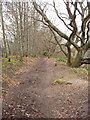
10

Riverside path at Brutus Bridge
Totnes footpath 17 climbs steps after passing beneath the bridge, to run upstream beside the River Dart. The view in the opposite direction is at Image
Image: © Derek Harper
Taken: 15 Oct 2021
0.04 miles