IMAGES TAKEN NEAR TO
South Street, TOTNES, TQ9 5DZ
Introduction
This page details the photographs taken nearby to South Street, TQ9 5DZ by members of the Geograph project.
The Geograph project started in 2005 with the aim of publishing, organising and preserving representative images for every square kilometre of Great Britain, Ireland and the Isle of Man.

There are currently over 7.5m images from over14,400 individuals and you can help contribute to the project by visiting https://www.geograph.org.uk
Image Map
Images are licensed for reuse under creativecommons.org/licenses/by-sa/2.0
Notes
- Clicking on the map will re-center to the selected point.
- The higher the marker number, the further away the image location is from the centre of the postcode.
Image Listing (822 Images Found)
Images are licensed for reuse under creativecommons.org/licenses/by-sa/2.0
Image
Details
Distance
1
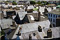
Roofscape Totnes
The view from the castle is extensive but the closer view of the town roofs is also worth a photo or two.
Image: © Chris Denny
Taken: 27 May 2015
0.00 miles
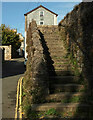
2
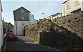
Baste Walls, Totnes
The Baste Walls are a "Late C14 southern circuit of the Totnes Town wall ... extensively repaired in circa 1639" https://www.historicengland.org.uk/listing/the-list/list-entry/1236962 . The upper and lower parts of South Street, linked here by a flight of steps, reunite further west. The house in between them, on the wall, is "Possibly [a] late C14 defensive tower" https://www.historicengland.org.uk/listing/the-list/list-entry/1264388 .
Image: © Derek Harper
Taken: 11 Apr 2017
0.02 miles
3
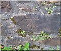
Ordnance Survey Cut Mark
This OS cut mark can be found on the wall north side of South Street. It marks a point 23.174m above mean sea level.
Image: © Adrian Dust
Taken: 25 Mar 2019
0.02 miles
4
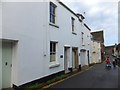
Houses and an unusual doorway in South Street, Totnes
The stone doorway appears to be medieval.
Image: © David Smith
Taken: 22 Oct 2013
0.02 miles
5

Steps, South Street, Totnes
Linking South Street to, well, South Street; its two arms run either side of the town wall (the "Baste Walls"); see Image, which also shows number 10, (as does Image]). "The siting of the Baste Walls suggests that the northern raised section of South Street may originally have been a rampart walk" https://www.historicengland.org.uk/listing/the-list/list-entry/1236962 .
Image: © Derek Harper
Taken: 23 Aug 2018
0.03 miles
6
Steps, South Street, Totnes
A sightly different angle on Image The building in the background is "Possibly late C14 defensive tower on the circuit of the town wall" https://historicengland.org.uk/listing/the-list/list-entry/1264388 .
Image: © Derek Harper
Taken: 9 Oct 2020
0.03 miles
7
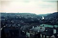
Totnes from the castle keep, 1975
A view south-eastward across the rooftops toward the River Dart in the distance.
Image: © FEG
Taken: Unknown
0.03 miles
8
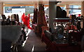
Totnes Market
Many of the more interesting stalls are to be found beneath the Civic Hall.
Image: © Derek Harper
Taken: 1 Dec 2017
0.03 miles
9
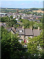
Totnes
"One of the most rewarding small towns in England" (Pevsner - he means architecturally). This view is dominated by the C15 red tower of St Mary's church. In the foreground, houses on Maudlin Road. Taken from a house on Kingsbridge Hill.
Image: © Derek Harper
Taken: 28 Jul 2006
0.03 miles
10
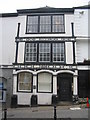
Ann Ball's house
A view to the south across High Street towards the house in which Ann Ball once lived.
Image: © Phil Williams
Taken: 9 May 2007
0.03 miles