IMAGES TAKEN NEAR TO
East Portlemouth, SALCOMBE, TQ8 8PQ
Introduction
This page details the photographs taken nearby to TQ8 8PQ by members of the Geograph project.
The Geograph project started in 2005 with the aim of publishing, organising and preserving representative images for every square kilometre of Great Britain, Ireland and the Isle of Man.

There are currently over 7.5m images from over14,400 individuals and you can help contribute to the project by visiting https://www.geograph.org.uk
Image Map
Images are licensed for reuse under creativecommons.org/licenses/by-sa/2.0
Notes
- Clicking on the map will re-center to the selected point.
- The higher the marker number, the further away the image location is from the centre of the postcode.
Image Listing (6 Images Found)
Images are licensed for reuse under creativecommons.org/licenses/by-sa/2.0
Image
Details
Distance
2
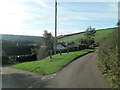
Rickham Farm
The fine farmhouse is on the left.
Image: © Bill Boaden
Taken: 28 Jun 2011
0.05 miles
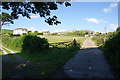
4
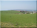
Farm land above Gara Rock
South Devon cattle grazing farm land above Gara Rock
Image: © Michael Smerdon
Taken: 21 Apr 2007
0.13 miles
5
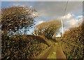
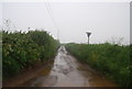
Lane from Gara Rock
The no through lane from Gara Rock passes wind-shaped trees as it nears the T-junction with the lane near Rickham.
Image: © Derek Harper
Taken: 29 Nov 2010
0.20 miles