IMAGES TAKEN NEAR TO
Aveton Gifford, KINGSBRIDGE, TQ7 4NJ
Introduction
This page details the photographs taken nearby to TQ7 4NJ by members of the Geograph project.
The Geograph project started in 2005 with the aim of publishing, organising and preserving representative images for every square kilometre of Great Britain, Ireland and the Isle of Man.

There are currently over 7.5m images from over14,400 individuals and you can help contribute to the project by visiting https://www.geograph.org.uk
Image Map
Images are licensed for reuse under creativecommons.org/licenses/by-sa/2.0
Notes
- Clicking on the map will re-center to the selected point.
- The higher the marker number, the further away the image location is from the centre of the postcode.
Image Listing (13 Images Found)
Images are licensed for reuse under creativecommons.org/licenses/by-sa/2.0
Image
Details
Distance
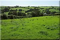
1
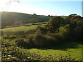
View near Knighton Coombe
Taken from the bend in the lane that twists down this valley towards the Avon (left), with hedges and fields towards Knowle.
Image: © Derek Harper
Taken: 4 Nov 2006
0.07 miles
2
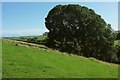
Above Boarshill
A summer version of the autumn scene in Image
Image: © Derek Harper
Taken: 27 Aug 2015
0.09 miles
3
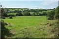
Farmland at Knowle
From the lane Between Combe Cross and Boarshill. A car drove very very slowly past me as I took this photo, its occupants inspecting me with great suspicion, and certainly not returning the jolly smile I offered them. Was I a migrant? Can't be too careful.
Image: © Derek Harper
Taken: 27 Aug 2015
0.12 miles
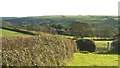
4
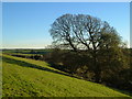
Above Boarshill
The valley on the right runs into the Avon estuary about 2 kilometres away. The farms and cottages that make up the hamlet of Boarshill are hidden behind the trees on the right. Seen from the lane between Knighton Coombe and Stoverlake.
Image: © Derek Harper
Taken: 4 Nov 2006
0.13 miles
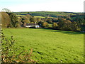
5
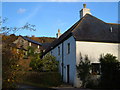
Boarshill
The cottage seen in Image, plus adjacent conversions, on a double bend in a South Hams lane.
Image: © Derek Harper
Taken: 18 Nov 2006
0.13 miles
6
Towards Knighton Coombe
Looking roughly south from the lane between Ley Cross and Coombe Cross in the South Hams, towards a valley that descends left towards the Avon estuary.
Image: © Derek Harper
Taken: 4 Nov 2006
0.13 miles
7
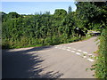
Lane passing Combe Farm Barns
Lane to Frogland passing Combe Farm Barns
Image: © Shaun Ferguson
Taken: 8 Aug 2010
0.14 miles
8
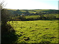
View near Combe Cross
Looking across fields towards Knowle, and Lower and Higher Cumery farms.
Image: © Derek Harper
Taken: 4 Nov 2006
0.15 miles
9
Boarshill
Cottages in the side of a South Hams valley heading towards the Avon estuary.
Image: © Derek Harper
Taken: 4 Nov 2006
0.19 miles
10
View over Boarshill
The valley of an unnamed stream, with a scattered farming hamlet around the remains of Combe Barton Barton - that's what the map says.
Image: © Derek Harper
Taken: 27 Aug 2015
0.19 miles