IMAGES TAKEN NEAR TO
Ringmore, KINGSBRIDGE, TQ7 4HN
Introduction
This page details the photographs taken nearby to TQ7 4HN by members of the Geograph project.
The Geograph project started in 2005 with the aim of publishing, organising and preserving representative images for every square kilometre of Great Britain, Ireland and the Isle of Man.

There are currently over 7.5m images from over14,400 individuals and you can help contribute to the project by visiting https://www.geograph.org.uk
Image Map (Loading...)


Getting Data...Please wait
Leaflet Map data © OpenStreetMap
Images are licensed for reuse under creativecommons.org/licenses/by-sa/2.0
Notes
- Clicking on the map will re-center to the selected point.
- The higher the marker number, the further away the image location is from the centre of the postcode.
Image Listing (34 Images Found)
Images are licensed for reuse under creativecommons.org/licenses/by-sa/2.0
Image
Details
Distance
1
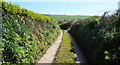
Track from Ringmore
The path to Bigbury follows the track for a while.
Image: © jeff collins
Taken: 9 Apr 2014
0.04 miles
2
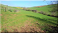
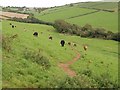
Pasture Land, above Challaborough
Looking up the valley towards the village of Bigbury.
Image: © jeff collins
Taken: 9 Apr 2014
0.10 miles
3
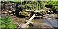
Walking the plank
The footbridge was washed away in the winter floods, this replacement is not really up to it. Easier to wade the stream. On the Bigbury-on-sea path.
Image: © jeff collins
Taken: 9 Apr 2014
0.13 miles
4
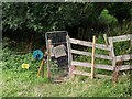
Electric fence and gate
Helpful to have things labelled in the countryside. Here we have "electric fence" and "gate". I was a little disappointed that "wood" and "bridge" were not similarly labelled. This is on Bigbury Footpath 7; once beyond the bridge it becomes Ringmore Footpath 13, the stream being a parish boundary.
Image: © Derek Harper
Taken: 31 Aug 2009
0.14 miles
5
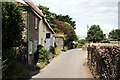
Ringmore
A narrow lane in Ringmore Village.
Image: © Tony Atkin
Taken: 8 Jul 2009
0.15 miles
6
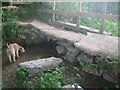
Stone bridge
Old stone bridge on a footpath outside Ringmore in the Challaborough valley.
Image: © Steve Carter
Taken: 4 Jul 2010
0.15 miles
7
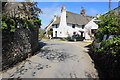
Thatched Cottage, Ringmore
From the road to Challaborough.
Image: © jeff collins
Taken: 9 Apr 2014
0.16 miles
8
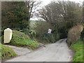
Lane to Challaborough
The lane leading down to Challaborough is very narrow - not much of a problem in December but it can get congested in high season.
Image: © Stephen McKay
Taken: 24 Dec 2016
0.19 miles
9
Valley above Challaborough
Not the same valley as the one shown in Image, but the more northerly of the two, seen from Ringmore Footpath 13. At the head of the valley is the village of Bigbury.
Image: © Derek Harper
Taken: 31 Aug 2009
0.20 miles
10
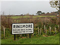
Please drive slowly through Ringmore
Arriving in Ringmore from Challaborough motorists are confronted with this large sign with the usual plea for safe driving.
Image: © Stephen McKay
Taken: 24 Dec 2016
0.20 miles