IMAGES TAKEN NEAR TO
Woodleigh, KINGSBRIDGE, TQ7 4DQ
Introduction
This page details the photographs taken nearby to TQ7 4DQ by members of the Geograph project.
The Geograph project started in 2005 with the aim of publishing, organising and preserving representative images for every square kilometre of Great Britain, Ireland and the Isle of Man.

There are currently over 7.5m images from over14,400 individuals and you can help contribute to the project by visiting https://www.geograph.org.uk
Image Map (Loading...)


Getting Data...Please wait
Leaflet Map data © OpenStreetMap
Images are licensed for reuse under creativecommons.org/licenses/by-sa/2.0
Notes
- Clicking on the map will re-center to the selected point.
- The higher the marker number, the further away the image location is from the centre of the postcode.
Image Listing (6 Images Found)
Images are licensed for reuse under creativecommons.org/licenses/by-sa/2.0
Image
Details
Distance
2
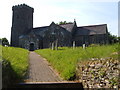
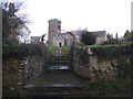
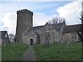
St Mary's church, Woodleigh
A simple church by the standards of the area, C14, with battlemented tower. Seen from the gate onto the lane through this very small village above the Avon valley in the South Hams.
Image: © Derek Harper
Taken: 16 Jun 2006
0.09 miles
5
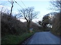
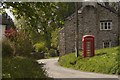
The north edge of Woodleigh
Road through woodland passing the sign for the village
Image: © David Smith
Taken: 27 Feb 2017
0.11 miles
6
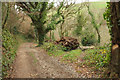
Track above Torr Brook
A route with public access from Woodleigh descends to cross the stream. An upended tree displays its root-plate. On the left is Watkins Wood, which is access land.
Image: © Derek Harper
Taken: 5 Dec 2019
0.25 miles