IMAGES TAKEN NEAR TO
Mead Lane, KINGSBRIDGE, TQ7 3PB
Introduction
This page details the photographs taken nearby to Mead Lane, TQ7 3PB by members of the Geograph project.
The Geograph project started in 2005 with the aim of publishing, organising and preserving representative images for every square kilometre of Great Britain, Ireland and the Isle of Man.

There are currently over 7.5m images from over14,400 individuals and you can help contribute to the project by visiting https://www.geograph.org.uk
Image Map (11 Images)


Getting Data...Please wait
Leaflet Map data © OpenStreetMap
Images are licensed for reuse under creativecommons.org/licenses/by-sa/2.0
Notes
- Clicking on the map will re-center to the selected point.
- The higher the marker number, the further away the image location is from the centre of the postcode.
Image Listing (11 Images Found)
Images are licensed for reuse under creativecommons.org/licenses/by-sa/2.0
Image
Details
Distance
3
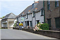
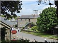
The Village Inn, Thurlestone
Thurlestone's pub is part of the complex that includes the Thurlestone Hotel and has been in the ownership of the same family since 1897. The building itself was originally a farmhouse dating from the 16th century.
Image: © Stephen McKay
Taken: 17 Aug 2019
0.22 miles
4
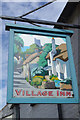
Sign for the Village Inn, Thurlestone
The sign depicts a suitably bucolic scene that includes elements that belong to Thurlestone, but the artist has taken considerable licence. A wider view of the pub can be seen here: Image
Image: © Stephen McKay
Taken: 17 Aug 2019
0.22 miles
6
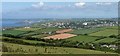
Thurlestone from near Galmpton Cross
A detail of the scene in Image], including Burgh Island, Bigbury Bay and part of South Huish at lower right.
Image: © Derek Harper
Taken: 8 Jun 2016
0.23 miles
8
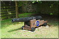
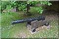
Cannon from the Canteloupe, Thurlestone
This old cannon stands on Thurlestone's village street immediately opposite the post office. According to the blue plaque it was raised from a 300 ton barque, the Canteloupe, which was wrecked on Thurlestone Rock in 1772. She was on her way home from Grenada to London with a cargo of sugar, coffee and rum; 13 crew and seven passengers were aboard, only one of whom survived - the rest are buried in Thurlestone churchyard. At the time the infamous slave trade triangle would have been in operation, the last leg of which brought goods from the American and Caribbean colonies to Britain, although there appears to be no specific evidence that the Canteloupe was involved.
Image: © Stephen McKay
Taken: 17 Aug 2019
0.24 miles
9
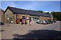
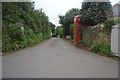
Thurlestone Village Shop and Post Office
This looks very much like it might be converted agricultural building.
Image: © Tony Atkin
Taken: 9 Aug 2009
0.25 miles