IMAGES TAKEN NEAR TO
Thurlestone, KINGSBRIDGE, TQ7 3NP
Introduction
This page details the photographs taken nearby to TQ7 3NP by members of the Geograph project.
The Geograph project started in 2005 with the aim of publishing, organising and preserving representative images for every square kilometre of Great Britain, Ireland and the Isle of Man.

There are currently over 7.5m images from over14,400 individuals and you can help contribute to the project by visiting https://www.geograph.org.uk
Image Map
Images are licensed for reuse under creativecommons.org/licenses/by-sa/2.0
Notes
- Clicking on the map will re-center to the selected point.
- The higher the marker number, the further away the image location is from the centre of the postcode.
Image Listing (66 Images Found)
Images are licensed for reuse under creativecommons.org/licenses/by-sa/2.0
Image
Details
Distance
1
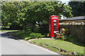
Old telephone box, Thurlestone
In common with many other telephone boxes in rural areas this one no longer accommodates a phone. It is, however, still in use as a book exchange.
Image: © Stephen McKay
Taken: 17 Aug 2019
0.02 miles
3
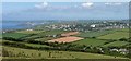
Thurlestone from near Galmpton Cross
A detail of the scene in Image], including Burgh Island, Bigbury Bay and part of South Huish at lower right.
Image: © Derek Harper
Taken: 8 Jun 2016
0.02 miles
5
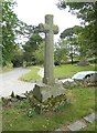
Old Wayside Cross - moved to Thurlestone churchyard
Thurlestone churchyard Cross, old head and shaft in a new cross, by the footpath, in parish of Thurlestone (South Hams District), on the Southwest edge of the graveyard of the church, overlooking Eddystone Road (was moved here from Whitley Farm), high on a stone retaining wall.
Devon & Dartmoor HER listed.
HER Number: MDV2789. https://www.heritagegateway.org.uk/Gateway/Results_Single.aspx?uid=MDV2789&resourceID=104
Surveyed
Milestone Society National ID: DVSH_THU
Image: © Alan Rosevear
Taken: 30 Jul 2012
0.02 miles
6
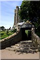
The Lych Gate to Thurlestone Church
The church tower can be seen in the background.
Image: © Tony Atkin
Taken: 9 Aug 2009
0.02 miles
7
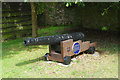
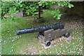
Cannon from the Canteloupe, Thurlestone
This old cannon stands on Thurlestone's village street immediately opposite the post office. According to the blue plaque it was raised from a 300 ton barque, the Canteloupe, which was wrecked on Thurlestone Rock in 1772. She was on her way home from Grenada to London with a cargo of sugar, coffee and rum; 13 crew and seven passengers were aboard, only one of whom survived - the rest are buried in Thurlestone churchyard. At the time the infamous slave trade triangle would have been in operation, the last leg of which brought goods from the American and Caribbean colonies to Britain, although there appears to be no specific evidence that the Canteloupe was involved.
Image: © Stephen McKay
Taken: 17 Aug 2019
0.03 miles
10
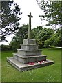
Thurlestone war memorial
It lists twelve deaths from WW1 and eleven from WW2, but the memorial in the church lists twelve from WW2
Image: © David Smith
Taken: 1 Jul 2016
0.03 miles