IMAGES TAKEN NEAR TO
Malborough, KINGSBRIDGE, TQ7 3DR
Introduction
This page details the photographs taken nearby to TQ7 3DR by members of the Geograph project.
The Geograph project started in 2005 with the aim of publishing, organising and preserving representative images for every square kilometre of Great Britain, Ireland and the Isle of Man.

There are currently over 7.5m images from over14,400 individuals and you can help contribute to the project by visiting https://www.geograph.org.uk
Image Map (Loading...)


Getting Data...Please wait
Leaflet Map data © OpenStreetMap
Images are licensed for reuse under creativecommons.org/licenses/by-sa/2.0
Notes
- Clicking on the map will re-center to the selected point.
- The higher the marker number, the further away the image location is from the centre of the postcode.
Image Listing (17 Images Found)
Images are licensed for reuse under creativecommons.org/licenses/by-sa/2.0
Image
Details
Distance
2
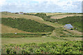
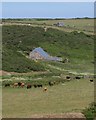
Barn and farm, Starehole Bottom
The barn, shippon and foldyard are "Probably late C17 or C18" https://www.historicengland.org.uk/listing/the-list/list-entry/1306684 . Up the valley side is East Soar Farm.
Image: © Derek Harper
Taken: 9 Jun 2018
0.11 miles
3
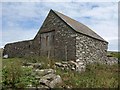
Malborough: barn at East Soar
Above Starehole Bottom
Image: © Martin Bodman
Taken: 3 Jul 2008
0.15 miles
4
![A coastal walk around Bolt Head and The Warren [36]](https://s0.geograph.org.uk/geophotos/07/60/36/7603628_76ecb1de_120x120.jpg)
A coastal walk around Bolt Head and The Warren [36]
Seen from the path is this field barn, foldyard and shippon (cattle shed). The barn was probably built in the late 17th or 18th century, with the shippon added in the 19th century. Constructed of local rubble stone with some cob under a half-hipped corrugated iron roof to the barn and a slate roof to the shippon. Listed, grade II, with details at: https://historicengland.org.uk/listing/the-list/list-entry/1306684 In the distance is a second field barn and foldyard with a closer view at Image
Beginning at Bolt Head Airfield car park, the route takes the road eastwards to East Soar Farm and then across fields to Sharp Tor and Starehole Bottom. Turning south onto the South West Coast Path, an ascent of Bolt Head follows before heading west up to and along the plateau known as The Warren. Turning inland and north, the route goes via Lower and Higher Soar before a minor road heads southeast back to the starting point. About 4¾ miles.
Image: © Michael Dibb
Taken: 27 Jun 2023
0.15 miles
5
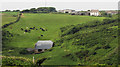
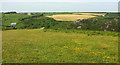
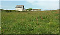
Looking towards East Soar Farm
East Soar farm, on the horizon, was acquired by the National Trust in 1935.
The traditional field patterns and stone walls are being restored.
Image: © Robin Drayton
Taken: 27 Apr 2010
0.16 miles
6
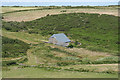
Barns near East Soar
A view from the gate shown in Image, looking across Starehole Bottom. The nearer group of buildings, a barn, foldyard and shippon, are described at http://www.britishlistedbuildings.co.uk/en-100762-barn-shippon-and-foldyard-wall-about-200 .
Image: © Derek Harper
Taken: 20 Jun 2010
0.17 miles
7
Across Starehole Bottom
Image: © Derek Harper
Taken: 9 Jun 2018
0.18 miles
8
Barn above Starehole Bottom
Malborough Footpath 15 and Malborough Footpath 7 meet here to become Salcombe Footpath 18 to the left of the barn, as the right of way crosses a parish boundary.
Image: © Derek Harper
Taken: 6 Aug 2011
0.19 miles
9
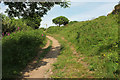
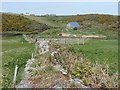
Path above Starehole Bottom
Salcombe footpath 41 approaches a junction, marked by the signpost. The continuation ahead is numbered Salcombe footpath 18; number 41 takes the left turn and almost immediately crosses the parish boundary into Malborough, at a further path junction.
Image: © Derek Harper
Taken: 9 Jun 2018
0.20 miles
10
Barn near East Soar Farm
Passed by a pair of footpaths; Salcombe footpath 18 runs past the rear wall.
Image: © Derek Harper
Taken: 9 Jun 2018
0.20 miles