IMAGES TAKEN NEAR TO
Bantham, KINGSBRIDGE, TQ7 3AP
Introduction
This page details the photographs taken nearby to TQ7 3AP by members of the Geograph project.
The Geograph project started in 2005 with the aim of publishing, organising and preserving representative images for every square kilometre of Great Britain, Ireland and the Isle of Man.

There are currently over 7.5m images from over14,400 individuals and you can help contribute to the project by visiting https://www.geograph.org.uk
Image Map (Loading...)


Getting Data...Please wait
Leaflet Map data © OpenStreetMap
Images are licensed for reuse under creativecommons.org/licenses/by-sa/2.0
Notes
- Clicking on the map will re-center to the selected point.
- The higher the marker number, the further away the image location is from the centre of the postcode.
Image Listing (56 Images Found)
Images are licensed for reuse under creativecommons.org/licenses/by-sa/2.0
Image
Details
Distance
1
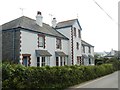
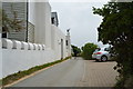
Terraced coastguard cottages, Bantham
Because the road is narrow, it is difficult to obtain a picture of this building from the opposite side. (Image required digital manipulation) The four cottages were once called the Coastguard Station
Image: © David Smith
Taken: 1 May 2019
0.05 miles
2
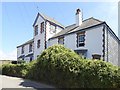
Former coastguard building, Bantham
The block now has four dwellings. The Victorian map calls this Coastguard Station
Image: © David Smith
Taken: 23 Jul 2018
0.06 miles
4

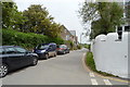
Avon Estuary Walk
The Avon estuary walk heading away from Bantham
Image: © Shaun Ferguson
Taken: 22 Jul 2009
0.08 miles
5
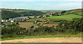
Bantham
The village straddles an easting gridline. Everything to the right of the white building on the left is in SX6743. The line of buildings climbing the hill to the right is on the road to Kingsbridge.
Behind is the estuary of the Avon; the buildings amidst the woods on the far side are in Image
Seen across the Buckland Stream valley from the same spot as Image
Image: © Derek Harper
Taken: 24 Sep 2009
0.08 miles
6
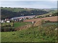
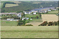
East side of Bantham
From up on the ridge separating the Buckland Stream valley (foreground) from the Thurlestone Stream valley. Over the next ridge (on which the village sits) is the Avon estuary.
Image: © Derek Harper
Taken: 15 Jun 2022
0.08 miles
7
Bantham and the River Avon
Looking down from a path on the hillside to Bantham village and the Avon estuary.
Image: © Stephen McKay
Taken: 17 Aug 2019
0.08 miles
9
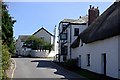
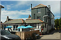
Bantham
Bantham is little more than a hamlet situated next to what is probably the most popular surfing beach on the south coast. The Sloop Inn on the right of the street dates from the 14th century.
Image: © Tony Atkin
Taken: 9 Aug 2009
0.09 miles
10
Sloop Inn, Bantham
"C17 origins ..." https://historicengland.org.uk/listing/the-list/list-entry/1324946?section=official-list-entry . Thurlestone footpath 4 runs alongside.
Image: © Derek Harper
Taken: 15 Jun 2022
0.10 miles