IMAGES TAKEN NEAR TO
West Buckland, KINGSBRIDGE, TQ7 3AF
Introduction
This page details the photographs taken nearby to TQ7 3AF by members of the Geograph project.
The Geograph project started in 2005 with the aim of publishing, organising and preserving representative images for every square kilometre of Great Britain, Ireland and the Isle of Man.

There are currently over 7.5m images from over14,400 individuals and you can help contribute to the project by visiting https://www.geograph.org.uk
Image Map
Images are licensed for reuse under creativecommons.org/licenses/by-sa/2.0
Notes
- Clicking on the map will re-center to the selected point.
- The higher the marker number, the further away the image location is from the centre of the postcode.
Image Listing (5 Images Found)
Images are licensed for reuse under creativecommons.org/licenses/by-sa/2.0
Image
Details
Distance
1
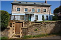
Burnt House
On the edge of East Buckland village. Totally renovated some years ago now a holiday let.
Image: © jeff collins
Taken: 6 Aug 2014
0.10 miles
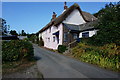
3
Track towards Bantham
The path from East Buckland is to the left of my position, behind me the track goes on towards North Upton.
Image: © jeff collins
Taken: 6 Aug 2014
0.15 miles
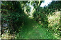
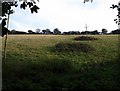
4
Meadow, East Buckland
In the valley of the Buckland Stream. The lane leads up to Clanacombe and Western Cross.
Image: © Derek Harper
Taken: 24 Sep 2009
0.15 miles
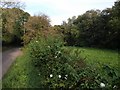
5
Hillside, East Buckland
Bramble patches adorn this steep hillside on the south side of the Buckland Stream valley.
Image: © Derek Harper
Taken: 24 Sep 2009
0.23 miles