IMAGES TAKEN NEAR TO
Hawthorn Close, KINGSBRIDGE, TQ7 1TB
Introduction
This page details the photographs taken nearby to Hawthorn Close, TQ7 1TB by members of the Geograph project.
The Geograph project started in 2005 with the aim of publishing, organising and preserving representative images for every square kilometre of Great Britain, Ireland and the Isle of Man.

There are currently over 7.5m images from over14,400 individuals and you can help contribute to the project by visiting https://www.geograph.org.uk
Image Map
Images are licensed for reuse under creativecommons.org/licenses/by-sa/2.0
Notes
- Clicking on the map will re-center to the selected point.
- The higher the marker number, the further away the image location is from the centre of the postcode.
Image Listing (24 Images Found)
Images are licensed for reuse under creativecommons.org/licenses/by-sa/2.0
Image
Details
Distance
2
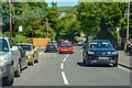
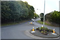
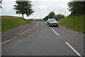
Kingsbridge : West Alvington Hill A381
Looking along the road.
Image: © Lewis Clarke
Taken: 8 Jun 2021
0.16 miles
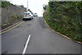
6
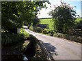
Tacketwood Bridge
The lane from Kingsbridge south towards Collapit crosses a small stream from West Alvington that, immediately below the bridge, forms a side creek of the Kingsbridge estuary.
Image: © Derek Harper
Taken: 1 Oct 2009
0.19 miles
8
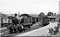
Kingsbridge Station, with a '4575' 2-6-2T
View eastward, towards the buffer-stops: ex-GW terminus of the branch from Brent, closed 16/9/63. The locomotive, No. 5558 (built 11/28, withdrawn 10/60) is running round the branch train standing at the platform.
Image: © Ben Brooksbank
Taken: 24 Jul 1958
0.20 miles
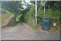
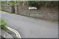
9

Old Boundary Marker by the A381, West Alvington Hill
Parish Boundary Marker by the A381, in parish of West Alvington (South Hams District), West Alvington Hill, West of entrance to Kingsbridge Community College, on grass bank beside village sign.
Surveyed
Milestone Society National ID: DV_KBSC01pb
Image: © Alan Rosevear
Taken: 25 Feb 2013
0.20 miles