IMAGES TAKEN NEAR TO
Creek Road, DARTMOUTH, TQ6 9TG
Introduction
This page details the photographs taken nearby to Creek Road, TQ6 9TG by members of the Geograph project.
The Geograph project started in 2005 with the aim of publishing, organising and preserving representative images for every square kilometre of Great Britain, Ireland and the Isle of Man.

There are currently over 7.5m images from over14,400 individuals and you can help contribute to the project by visiting https://www.geograph.org.uk
Image Map (Loading...)


Getting Data...Please wait
Leaflet Map data © OpenStreetMap
Images are licensed for reuse under creativecommons.org/licenses/by-sa/2.0
Notes
- Clicking on the map will re-center to the selected point.
- The higher the marker number, the further away the image location is from the centre of the postcode.
Image Listing (52 Images Found)
Images are licensed for reuse under creativecommons.org/licenses/by-sa/2.0
Image
Details
Distance
1
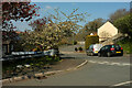
Junction, Townstal
Hermitage Road meets Archway Drive. Both are no through roads.
Image: © Derek Harper
Taken: 18 Apr 2021
0.11 miles
2
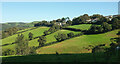
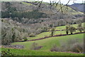
Hillside above Old Mill Creek
Looking right from Image], with much overlap to include a glimpse of the Dart on the left. The houses are on Creek Road and Archway Drive.
Image: © Derek Harper
Taken: 27 Sep 2020
0.13 miles
3
Archway Drive, Townstal
Taken just north of junction with Mill Crescent.
Image: © Derek Harper
Taken: 18 Apr 2021
0.14 miles
4
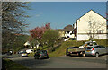
Hermitage Road, Townstal
A cul-de-sac on the edge of Dartmouth's built-up area.
Image: © Derek Harper
Taken: 18 Apr 2021
0.15 miles
6
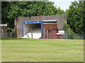
Britannia Royal Naval College - what is this?
This building is behind a security fence in an already secure site and there is a warning notice to say no admission when the red flag is flying. Sounds dangerous - but what is its use?
Image: © Chris Allen
Taken: 8 Jul 2017
0.17 miles
7
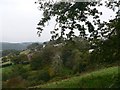
View to the north of Townstal
At this point in our walk we are leaving the village of Townstal. From here the narrow country lane descends steeply downhill to Old Mill. To our right (NE) we look over rolling hillside towards the Dart estuary. The outlying houses of the village are visible among the trees.
Image: © Wendy North
Taken: 13 Oct 2007
0.17 miles
9
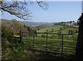
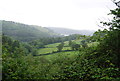
View above Old Mill Creek
Seen through a gateway from Old Mill Lane, a steep lane between Old Mill Bridge and Townstal. There is a glimpse of the River Dart left of centre. See also Image and Image
Image: © Derek Harper
Taken: 20 Apr 2009
0.18 miles
10
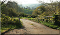
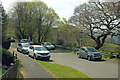
Entrance to sewage works
An open gate by Hermitage Road, with a view over the Old Mill Creek valley.
Image: © Derek Harper
Taken: 18 Apr 2021
0.19 miles