IMAGES TAKEN NEAR TO
Clarence Hill, DARTMOUTH, TQ6 9NY
Introduction
This page details the photographs taken nearby to Clarence Hill, TQ6 9NY by members of the Geograph project.
The Geograph project started in 2005 with the aim of publishing, organising and preserving representative images for every square kilometre of Great Britain, Ireland and the Isle of Man.

There are currently over 7.5m images from over14,400 individuals and you can help contribute to the project by visiting https://www.geograph.org.uk
Image Map
Images are licensed for reuse under creativecommons.org/licenses/by-sa/2.0
Notes
- Clicking on the map will re-center to the selected point.
- The higher the marker number, the further away the image location is from the centre of the postcode.
Image Listing (705 Images Found)
Images are licensed for reuse under creativecommons.org/licenses/by-sa/2.0
Image
Details
Distance
1
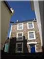
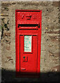
Victorian postbox, Dartmouth
Image places Image] in context looking up Clarence Hill; this looks downhill, with an attractive slate-hung facade just beyond.
Image: © Derek Harper
Taken: 27 Sep 2020
0.01 miles
2
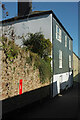
House on Clarence Hill, Dartmouth
Seen from Browns Hill, looking up the last flight of steps; the house is on the junction. The C18 house has some original sashes. http://www.imagesofengland.org.uk/Details/Default.aspx?id=387205&mode=adv
Image: © Derek Harper
Taken: 27 Sep 2009
0.01 miles
3
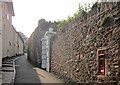
Clarence Hill, Dartmouth
With a Victorian postbox on the right. According to an online source it's number TQ6 160, but it carries no identifying plate itself (but see Image]). This lane is used by the Dart Valley Trail.
Image: © Derek Harper
Taken: 5 Sep 2014
0.02 miles
4
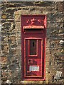
Victorian postbox, Dartmouth
Also shown in Image According to http://dracos.co.uk/made/nearest-postbox/ , it's number TQ6 160, but there is no identifying plate. The attached label tells you that, "from the 15th September 2014, the final collection from this postbox will be made no earlier than 9.00 am Monday to Friday and 7.00 Saturday. the latest collection time for this area is shown on the postbox notice". I wonder if the person who affixed that saw the problem.
Update: Six years on, and the plate has been replaced and the box painted Image
Image: © Derek Harper
Taken: 5 Sep 2014
0.02 miles
5
Victorian postbox, Dartmouth
Almost unrecognisable from Image, with a fresh coat of paint and its plate replaced, though graffiti has been added. Fortunately it hasn't obscured the crucial confirmation that this is indeed number TQ6 160.
Image: © Derek Harper
Taken: 27 Sep 2020
0.02 miles
6
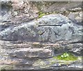
Ordnance Survey Cut Mark
This OS cut mark can be found on the wall of No40 Clarence Hill. It marks a point 31.056m above mean sea level.
Image: © Adrian Dust
Taken: 28 Mar 2019
0.02 miles
8
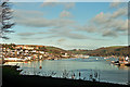
The Estuary of the River Dart at Dartmouth
Features Dartmouth town on the western side of the estuary (SX8751) and the tip of Kingswear on the eastern side.
Image: © Richard Baker
Taken: Unknown
0.03 miles
9
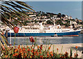
Dartmouth, The "Caledonian Star" in the Harbour
Seen at anchor in the Harbour, the "Caledonian Star" was on a cruise round the British Isles.
Image: © Neil Kennedy
Taken: 19 May 1991
0.03 miles
10
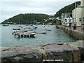
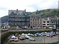
Bayards Cove Dartmouth
My wife & I have spent many happy hours here at Bayards Cove
Image: © Leonard Sperring
Taken: 21 Sep 2004
0.03 miles