IMAGES TAKEN NEAR TO
Burlestone, DARTMOUTH, TQ6 0LW
Introduction
This page details the photographs taken nearby to TQ6 0LW by members of the Geograph project.
The Geograph project started in 2005 with the aim of publishing, organising and preserving representative images for every square kilometre of Great Britain, Ireland and the Isle of Man.

There are currently over 7.5m images from over14,400 individuals and you can help contribute to the project by visiting https://www.geograph.org.uk
Image Map (Loading...)


Getting Data...Please wait
Leaflet Map data © OpenStreetMap
Images are licensed for reuse under creativecommons.org/licenses/by-sa/2.0
Notes
- Clicking on the map will re-center to the selected point.
- The higher the marker number, the further away the image location is from the centre of the postcode.
Image Listing (25 Images Found)
Images are licensed for reuse under creativecommons.org/licenses/by-sa/2.0
Image
Details
Distance
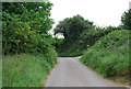
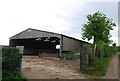
1
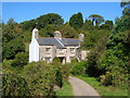
Lower Burlestone
An old farmhouse with jetty porch beside a small tributary of the Gara.
Image: © Derek Harper
Taken: 7 Sep 2006
0.02 miles
6
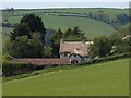
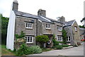
The Old Farmhouse, Burlestone
Seen from the junction shown in Image The beautifully thatched farmhouse is C17, and, like many houses in the area, of considerable interest architecturally http://www.imagesofengland.org.uk/Details/Default.aspx?id=100025&mode=adv .
Image: © Derek Harper
Taken: 23 May 2009
0.05 miles
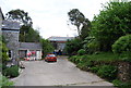
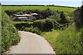
7
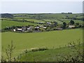
Burlestone
A view over the hamlet from the lane on the right of Image The woods in the distance are in the valley of The Gara, in Image and Image
Image: © Derek Harper
Taken: 23 May 2009
0.05 miles
8
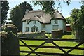
Thatched house, Burlestone
The Old Farmhouse, also shown in Image is "Circa early to mid C17 extended in circa C18" https://www.historicengland.org.uk/listing/the-list/list-entry/1325180 (a detailed historical description which also includes the garden wall).
Image: © Derek Harper
Taken: 13 Jun 2017
0.06 miles
10
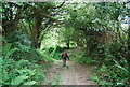
Burlestone
The farming hamlet is tucked into the head of the valley of a small tributary of the Gara.
Image: © Derek Harper
Taken: 13 Jun 2017
0.07 miles