IMAGES TAKEN NEAR TO
Weeke Hill, DARTMOUTH, TQ6 0JT
Introduction
This page details the photographs taken nearby to Weeke Hill, TQ6 0JT by members of the Geograph project.
The Geograph project started in 2005 with the aim of publishing, organising and preserving representative images for every square kilometre of Great Britain, Ireland and the Isle of Man.

There are currently over 7.5m images from over14,400 individuals and you can help contribute to the project by visiting https://www.geograph.org.uk
Image Map
Images are licensed for reuse under creativecommons.org/licenses/by-sa/2.0
Notes
- Clicking on the map will re-center to the selected point.
- The higher the marker number, the further away the image location is from the centre of the postcode.
Image Listing (48 Images Found)
Images are licensed for reuse under creativecommons.org/licenses/by-sa/2.0
Image
Details
Distance
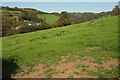
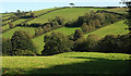
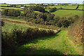
2
Catch meadow at Little Weeke
Looking left from Image "An extensive catch meadow of probable 19th century date is visible as a series of earthwork ditches on aerial photographs ... Catch meadows provided a simple, inexpensive and effective form of irrigation ... water was diverted from a source such as a pond, river, spring or spring-fed stream and passed along the meadow slopes via one or more of the gutters, which was then caused to overflow. The lower, roughly parallel gutters then ‘caught’ and redistributed water passing it evenly over the surface of a meadow below. The gently flowing water prevented the ground freezing in winter and encouraged early growth in spring, thereby providing extra feed for livestock, particularly important during the hungry gap of the March and April. The catch meadow covers an area of approximately 5.8 hectares of northwest and south facing slope. The system comprises a series of gutters which measure less than 2m in width and appear to tap a number of spring-fed streams that rise to the west and south ..." https://www.heritagegateway.org.uk/Gateway/Results_Single.aspx?uid=MDV105218&resourceID=104 .
Image: © Derek Harper
Taken: 13 Sep 2020
0.08 miles
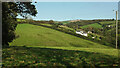
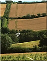
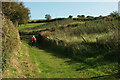
3
Meadow by Weeke Hill
The B3205 runs behind the trees on the left. Not obvious except at larger sizes is a pond in the central shadows. The meadow was an orchard in the C19, according to https://www.heritagegateway.org.uk/Gateway/Results_Single.aspx?uid=MDV43999&resourceID=104 and indeed an 1880s map online.
Image: © Derek Harper
Taken: 13 Sep 2020
0.08 miles
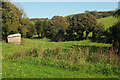
4
Trees by young wood, Weeke
Image: © Derek Harper
Taken: 4 Aug 2021
0.10 miles
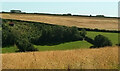
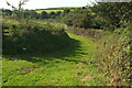
5
Valley, Week
A view from the rather dishevelled gate on the left of Image A house lurks above the little wood on the right. The NT land begins on the other side of the road down the valley.
Image: © Derek Harper
Taken: 13 Sep 2020
0.12 miles
6
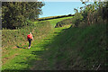
Diamond Jubilee Way above Weeke Cottage
Following Dartmouth Footpath 6 up the southern side of the valley seen in Image
Image: © Derek Harper
Taken: 13 Sep 2020
0.12 miles
7
Valley, Weeke
A view towards Weeke Cottage from Swannaton. Beyond it, Dartmouth footpath 6 climbs beside a hedge.
Image: © Derek Harper
Taken: 4 Aug 2021
0.12 miles
8
Diamond Jubilee Way near Weeke Cottage
Image: © Derek Harper
Taken: 13 Sep 2020
0.13 miles
9
Path to Weeke Cottage
Taken lower down Dartmouth footpath 6 than Image
Image: © Derek Harper
Taken: 13 Sep 2020
0.13 miles
10
Diamond Jubilee Way at Weeke Cottage
A little further up Dartmouth Footpath 6 from Image After the gate, the path turns right to climb more steeply.
Image: © Derek Harper
Taken: 13 Sep 2020
0.13 miles