IMAGES TAKEN NEAR TO
Dittisham, DARTMOUTH, TQ6 0HW
Introduction
This page details the photographs taken nearby to TQ6 0HW by members of the Geograph project.
The Geograph project started in 2005 with the aim of publishing, organising and preserving representative images for every square kilometre of Great Britain, Ireland and the Isle of Man.

There are currently over 7.5m images from over14,400 individuals and you can help contribute to the project by visiting https://www.geograph.org.uk
Image Map
Images are licensed for reuse under creativecommons.org/licenses/by-sa/2.0
Notes
- Clicking on the map will re-center to the selected point.
- The higher the marker number, the further away the image location is from the centre of the postcode.
Image Listing (9 Images Found)
Images are licensed for reuse under creativecommons.org/licenses/by-sa/2.0
Image
Details
Distance
1
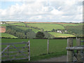
View towards Chipton
This view from near the corner of Norton Park provides a connection between the views in Image, left, and Image, right.
The track in the foreground, also seen in Image, appears to be a new access to Lower Norton Farm. High on the hillside, left, is Bruckton in SX8452.
Image: © Robin Stott
Taken: 16 Sep 2011
0.05 miles
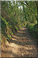
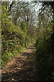
2
Track from Downton
The lane is descending the eastern slopes of a twisting side valley that is here curving to the left.
Image: © Derek Harper
Taken: 18 Apr 2021
0.16 miles
3

Track from Downton
A green lane on a long descent from the farms at Downton and Lapthorne to the valley west of Old Mill Creek.
Image: © Derek Harper
Taken: 18 Apr 2021
0.16 miles
4
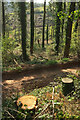
Woodland near Chipton
Many tracks cross the steep woodland, and the foreground stumps show that activity is taking place, though not today. This was taken close to Image
Image: © Derek Harper
Taken: 18 Apr 2021
0.18 miles
5
Track from Downton
Further up the green lane shown in Image], though looking down it.
Image: © Derek Harper
Taken: 18 Apr 2021
0.20 miles
6
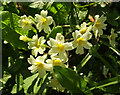
Primroses near Chipton
By the public access route shown on the right of Image
Image: © Derek Harper
Taken: 18 Apr 2021
0.21 miles
7
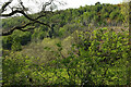
Woods above Chipton
A view across the side valley from the green lane shown in Image
Image: © Derek Harper
Taken: 18 Apr 2021
0.22 miles
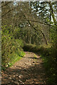
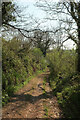
8
Green lane from Downton
This public access route is heading gently downhill, but it will become much steeper later on.
Image: © Derek Harper
Taken: 18 Apr 2021
0.22 miles