IMAGES TAKEN NEAR TO
Springdale Close, BRIXHAM, TQ5 9RL
Introduction
This page details the photographs taken nearby to Springdale Close, TQ5 9RL by members of the Geograph project.
The Geograph project started in 2005 with the aim of publishing, organising and preserving representative images for every square kilometre of Great Britain, Ireland and the Isle of Man.

There are currently over 7.5m images from over14,400 individuals and you can help contribute to the project by visiting https://www.geograph.org.uk
Image Map
Images are licensed for reuse under creativecommons.org/licenses/by-sa/2.0
Notes
- Clicking on the map will re-center to the selected point.
- The higher the marker number, the further away the image location is from the centre of the postcode.
Image Listing (15 Images Found)
Images are licensed for reuse under creativecommons.org/licenses/by-sa/2.0
Image
Details
Distance
1
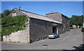
The Old Dairy, Brixham
Now used by several engineering firms, this can be seen on the right of Image
Image: © Derek Harper
Taken: 12 Jun 2014
0.06 miles
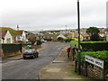
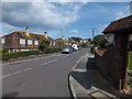
2
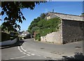
Junction, Higher Brixham
The junction of St Mary's Road (right and ahead) with Upton Manor Park. On the right is the Old Dairy - see Image
Image: © Derek Harper
Taken: 12 Jun 2014
0.06 miles
3
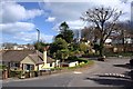
Road Junction in Higher Brixham
A tree holds central place on the road junction between Castor Road and Upton Manor Road.
Image: © Tony Atkin
Taken: 4 Apr 2010
0.11 miles
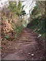
4
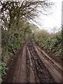
Muddy Lane, Southdown Hill, Higher Brixham
The mud reveals the extent to which vehicles use Yards Lane, quite narrow and probably unsuitable for this volume of traffic
Image: © Tom Jolliffe
Taken: 15 Mar 2007
0.11 miles
5
Upton Manor Farm, Brixham
"Welcome to Upton Manor Farm".
Image: © Derek Harper
Taken: 12 Jun 2014
0.12 miles
7
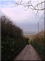
Lane down Southdown Hill, Higher Brixham
The high hedgerows and narrow lane is characteristic of South Devon. This road goes down towards Milton Street at the bottom.
Image: © Tom Jolliffe
Taken: 15 Mar 2007
0.14 miles
8
Public Footpath, Chisledon Hill, Higher Brixham
The lower part of this path consists of rocky layers under the canopy of the hedge and trees.
Image: © Tom Jolliffe
Taken: 15 Mar 1983
0.15 miles
9
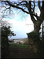
Gate near Yards Lane, Brixham
Looking down towards Berry Head and beyond
Image: © Tom Jolliffe
Taken: 15 Mar 2007
0.16 miles
10
Briseham Road in Brixham
Here are several houses with mansard roofs
Image: © David Smith
Taken: 31 Aug 2012
0.16 miles