IMAGES TAKEN NEAR TO
Orchard Grove, BRIXHAM, TQ5 9RH
Introduction
This page details the photographs taken nearby to Orchard Grove, TQ5 9RH by members of the Geograph project.
The Geograph project started in 2005 with the aim of publishing, organising and preserving representative images for every square kilometre of Great Britain, Ireland and the Isle of Man.

There are currently over 7.5m images from over14,400 individuals and you can help contribute to the project by visiting https://www.geograph.org.uk
Image Map
Images are licensed for reuse under creativecommons.org/licenses/by-sa/2.0
Notes
- Clicking on the map will re-center to the selected point.
- The higher the marker number, the further away the image location is from the centre of the postcode.
Image Listing (54 Images Found)
Images are licensed for reuse under creativecommons.org/licenses/by-sa/2.0
Image
Details
Distance
1
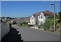
Castor Road, Brixham
Houses on the winding road through Higher Brixham.
Image: © Derek Harper
Taken: 12 Jun 2014
0.03 miles
2
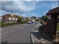
Briseham Road in Brixham
Here are several houses with mansard roofs
Image: © David Smith
Taken: 31 Aug 2012
0.06 miles
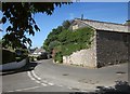
4
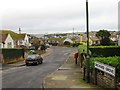
Road Junction in Higher Brixham
A tree holds central place on the road junction between Castor Road and Upton Manor Road.
Image: © Tony Atkin
Taken: 4 Apr 2010
0.08 miles
5
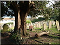
Graveyard, St Mary the Virgin, Higher Brixham
A stricken tree, a log and tombstones in the old peaceful graveyard.
Image: © Tom Jolliffe
Taken: 15 Mar 2007
0.10 miles
6
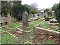
Chilcote graves at St Mary's Brixham
The three nearest graves contain members of the Chilcote family, some of Hill House nearby (see Image, some of St Marychurch (see Image).
Image: © David Hawgood
Taken: 25 Feb 2011
0.11 miles
7
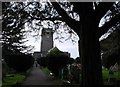
Graveyard pathway, St Mary the Virgin, Higher Brixham
Local people enjoy a stroll through the graveyard with its shade and calm.
Image: © Tom Jolliffe
Taken: 15 Mar 2007
0.11 miles
8
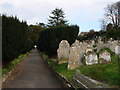
Tombstones, St Mary the Virgin, Higher Brixham
A path through a peaceful graveyard
Image: © Tom Jolliffe
Taken: 15 Mar 2007
0.12 miles
9
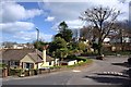
Junction, Higher Brixham
The junction of St Mary's Road (right and ahead) with Upton Manor Park. On the right is the Old Dairy - see Image
Image: © Derek Harper
Taken: 12 Jun 2014
0.12 miles
10

Castor Road, Brixham
On the right side of the road is the Spar shown in Image, with what I think are the West of England Steam Corn Mills behind it on the right, built in 1850. The large house past the supermarket is Castor House, perhaps formerly a farmhouse, described at http://list.english-heritage.org.uk/resultsingle.aspx?uid=1208614&searchtype=mapsearch .
Image: © Derek Harper
Taken: 12 Jun 2014
0.13 miles